Synopsis:
High pressure systems will continue to move in from Canada the next several days. The first high will sit over the region through early Thursday followed by a cool front Thursday night. The second high will move in on Friday. Dry, mainly sunny days are expected with cool nights.
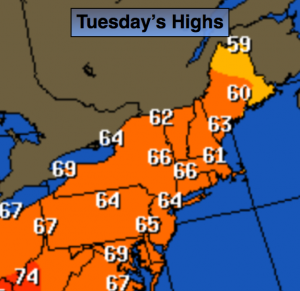
Today:
Morning frost inland. Sunny and cool with highs 60º-65º. The average high is 66º. Light Northeast to Southeast wind.
Tonight:
Becoming partly cloudy. Lows in the lower 50s in the City, the 30s inland. Light East wind.
Wednesday:
Sun and clouds. Highs in the mid to upper 60s.
Thursday:
Partly sunny and warmer with readings around 70º.
Friday:
Mostly sunny and cooler. Highs in the lower 60s.
Saturday:
Mostly sunny. Highs in the lower 60s.
Stay Tuned.
Keep it here for a no nonsense, no hype forecast.