Synopsis:
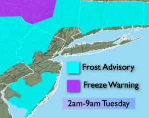
Strong high pressure will sit over the area tonight. Conditions are setting up for a frost to occur in many areas away from the coast and urban corridor tonight. With clear skies, nearly calm winds and temperatures in the 30’s scattered frost is possible. Some areas well inland in sheltered valleys maybe around freezing at daybreak. Time to bring in those tender plants and flowers.
The week will feature plenty of sunshine as a quiet weather pattern takes hold. Temperatures will creep up through Thursday and then drop again by Friday as another cool front pushes in.
Tonight:
Clear and chilly with scattered frost possible in colder areas. Lows in the upper 40s in the City, the 30s inland. Diminishing North wind at less than 5mph.
Tuesday:
Sunny and cool with highs 60º-65º. The average high is 66º.
Wednesday:
Sun and clouds. Highs in the mid to upper 60s.
Thursday:
Partly sunny and warmer with readings around 70º.
Friday:
Mostly sunny and cooler. Highs in the lower 60s.
Saturday:
Mostly sunny. Highs in the lower 60s.
Stay Tuned.
Keep it here for a no nonsense, no hype forecast.