Synopsis:
An area of high pressure over the Southeast dominate our weather through Saturday. This high will continue to pump up a hot and humid airmass. The potential of a late Summer September heat wave exists with readings flirting with 90º and high humidity through Saturday (some areas may not have 3 consecutive days of 90º or higher, which constitutes a heat wave, but it will be uncomfortable never the less). The heat index will be in the 90s. A cool front will sweep through Saturday night with limited showers or storms and a less humid Sunday.
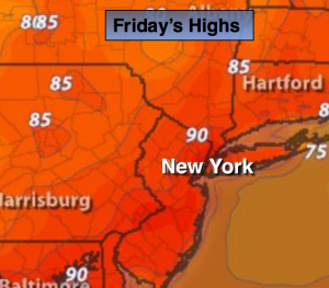
Today:
Hazy, hot and humid with highs near 90º. Northwest to Southwest wind at 5-10mph. A spotty late afternoon or evening storm is possible.
Tonight:
Spotty early storms, otherwise partly cloudy. Lows in the mid 70s in the City, around 70º inland. Winds becoming Northeast at 5mph.
Saturday:
Hazy, hot and humid with highs around 90º. A spotty late afternoon or evening storm is possible.
Sunday:
Partly sunny and less humid with highs in the mid 80s.
Monday:
Sunny and more seasonal with highs around 80º.
Tuesday:
Sunny with readings in the lower 80s.
This is the peak of hurricane season-early to mid September. The good news is, the tropics area quiet right now.
Stay Tuned.
Keep it here for a no nonsense, no hype forecast.