Synopsis:
A refreshing airmass courtesy of high pressure moving into the area from the North will dominate our weather through Saturday morning. A fine Friday is expected as many getaway for the long Labor Day Holiday Weekend. This issue is, there is a tropical storm to our South.
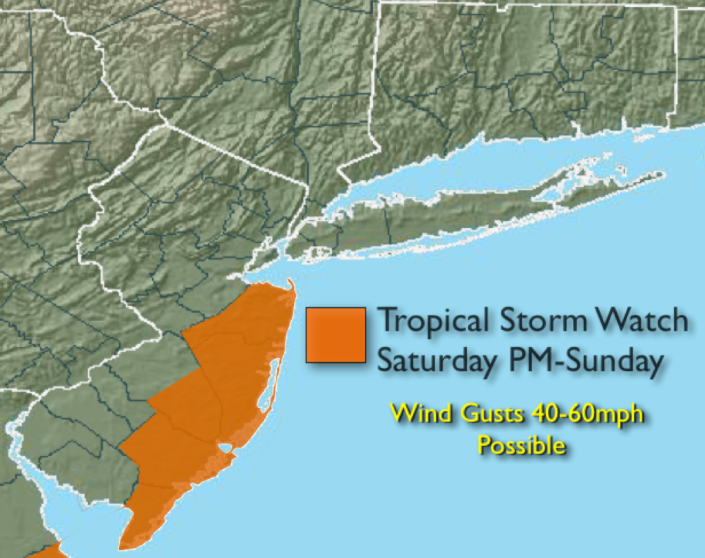
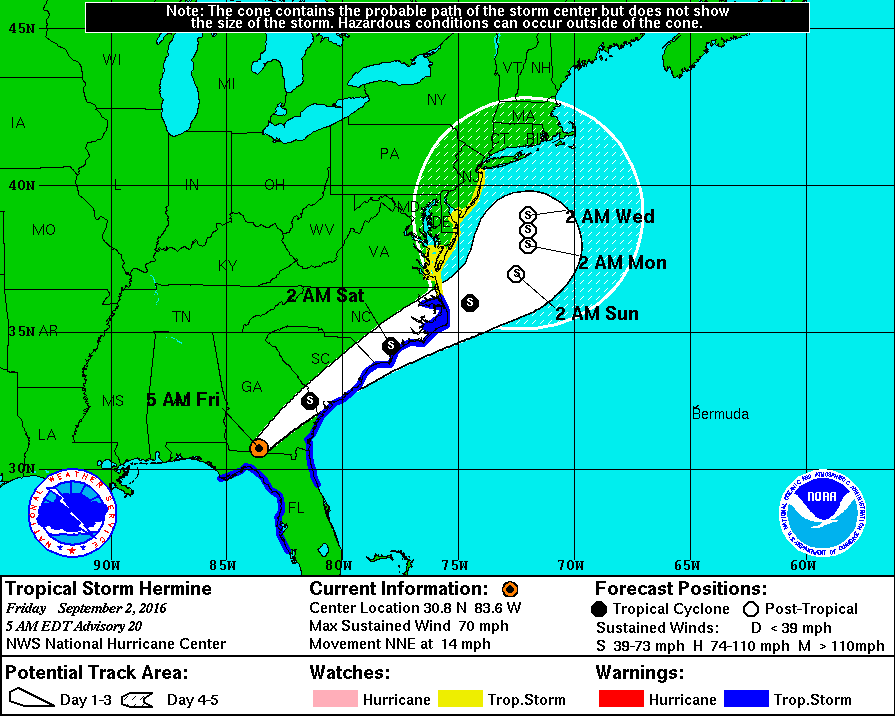
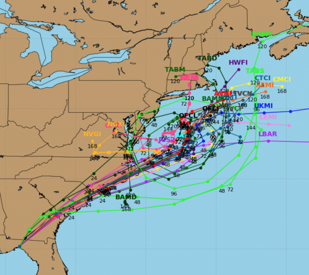
Tropical Storm Hermine will move Northeast through the coastal plain of Georgia and South Carolina today. The storm will exit the coast at the Outer Banks on Saturday. Most of the computer guidance is very similar in the Hermine’s track and intensity through the Labor Day Weekend. Upper level energy diving out of the Great Lakes within a large ridge of high pressure wants to capture Hermine and keep it close to the coast and slow it down. Where will the storm actually stall and possibly do a loop? Will it be too far off the coast to affect the area with rain and wind or will the storm be close enough to affect the area? There are two graphics above with tracks. The first is the National Hurricane Center track it has the storm taking a wide enough turn out to sea before stalling it early next week. This taken verbatim may keep the highest winds and heaviest bands of rain offshore. The second is the spaghetti plots (10-15 computer model tracks) which is similar to NHC’s output. A Tropical Storm Watch has been issued for Monmouth and Ocean counties for later Saturday into Labor Day. Winds gusts of 40-60mph are possible. Coastal flooding will be a major concern with several high tide cycles being affected by the storm. The storm is forecast to slow down and possibly stall- not a good thing. At the very least high surf and beach erosion is likely as the storm will take a couple of days to leave the Western Atlantic. A difference of 200 miles in the track could mean the difference between tropical storm force winds and heavy rain or little in the way of hazardous weather in our region. Again, the time frame is Sunday into Monday. Stay Tuned.
High surf and dangerous rip currents will be an issue at our local beaches. Please swim by guarded areas and heed the life guards warnings.
Today:
Sunny and pleasant highs around 80º. North wind at 8-12mph.
Tonight:
Partly cloudy. Lows in the mid 60s in the City, the mid 50s inland. Northeast wind at 5mph.
Saturday:
Morning sun, afternoon clouds. Rain is possible during the afternoon over Southern NJ. Highs in the mid to upper 70s.
Sunday:
Mostly Cloudy with a period of rain and wind possible. Tropical Storm conditions are possible along the NJ coast. Highs in the mid 70s.
Labor Day:
Mostly cloudy with showers possible. Tropical Storm conditions are possible along the NJ coast. Highs in the mid to upper 70s.
Tuesday:
Partly sunny with highs in the lower 80s.
Stay Tuned.
Keep it here for a no nonsense, no hype forecast.