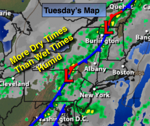
Synopsis:
A humid airmass coupled with an approaching weak cool front will spark spotty thunderstorms today. Much of the time will be rain-free with clouds and some sun. The greatest chance of thunderstorms will be toward evening and into the night. Some of the storms maybe severe, especially North and West of the City. High pressure will build in Wednesday into the July 4th weekend.
Today:
More clouds than sun, humid with highs in the 70s to around 80º. A spot thunderstorm is possible just about anytime, but the majority of the day will be dry. The storm threat will increase toward evening. Some of the storms maybe severe especially away from the coast. South/Southeast wind at 8-12mph.
Tonight:
Mostly cloudy and muggy with showers and thunderstorms. Again, some of the storms may contain strong winds. Lows around 70º in the City, the lower to mid 60s inland. Southeast to Southwest wind less than 5mph.
Wednesday:
Morning clouds will give way to partly sunny skies. Becoming less humid by afternoon. Highs in the lower 80s.
Thursday:
June’s finale will be a winner. Mostly sunny with highs mid 80s.
Friday:
Mostly sunny and warm for July’s debut. Readings will be in the mid 80s.
Saturday:
Plenty of sun. Highs in the mid 80s.
Stay Tuned.
Keep it here for a no nonsense, no hype forecast.