Synopsis:
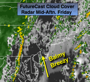
An onshore flow through today will result in clouds winning out the battle with the sun. It’ll be balmy and humid. A shower can’t be ruled out, but much of the time will be dry (FutureCast Cloud-Cover and Radar above).
A cold front and offshore storm will get their act together (combine) just offshore tonight & Saturday morning. Scattered showers are likely on the backside of these systems for the first half of Saturday. The storm will intensify rapidly as it moves into New England. Much colder air will filter in behind this system Saturday on a strong Northwest wind. Sunday will be fair and chilly with gusty winds.
Today:
A mix of clouds and some sun. Spotty showers are possible. The majority of the time will be dry. Balmy and humid with high in the lower to mid 70s. The average high for this time of the year is 63º. Southeast wind 8-15mph.
Tonight:
Mostly cloudy with scattered showers, much cooler by sunrise. Temperatures will remain in the 60’s until after midnight then drop into the 50s late. Winds becoming Northwest and increasing to 10-20mph by daybreak.
Saturday:
Scattered showers will give way to partly cloudy skies. Windy and much cooler. Highs will be in the mid to upper 50s. Winds will gusts up to 40mph making it feel like the 40s.
Sunday:
Partly sunny, breezy and cool. Highs in the upper 50s to around 60º.
Monday:
Partly sunny and seasonal. Highs in the lower 60s.
Tuesday:
Partly sunny. Chilly. Highs in the mid 50s.
Stay Tuned.
Keep it here for a no nonsense, no hype forecast.