Synopsis:
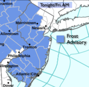
Tonight will most likely be the coldest night of the young Fall season so far. High pressure will usher in chilly air from Canada. A frost advisory has been posted for many areas in NJ.
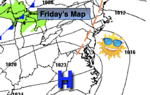
The sun will rule the sky Friday and Saturday as the high moves over and off to our East. Readings will near seasonable levels on Friday. A mild push is expected on Saturday around the backside of the departing high.
Partly sunny, mild conditions are expected for Sunday. A few showers are possible just about anytime as a weak weather system works in from the West. The majority of the day will be dry.
Temperature will go down in steps early next week as another shot of chilly air works in from the North.
Stay tuned.
Keep it here for a no nonsense, no hype forecast.
Tonight:
Clear. Chilly. Lows in the mid to upper 40s in the City, the 30s inland with scattered frost. Northwest winds diminishing to 5mph.
Friday:
Sunny. Highs in the mid to upper 60s. Northwest winds 5-10mph.
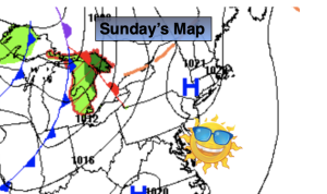
Saturday:
Mostly sunny. Mild. Highs in the lower to mid 70s.
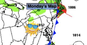
Sunday:
Sun and clouds. Shower possible. Highs around 70º.
Monday:
Partly sunny. Cooler. Highs in the mid 60s.
Tuesday:
Mostly sunny. Chilly. Highs in the mid to upper 50s.