Finally the Sun Dominates Sunday…


Synopsis:

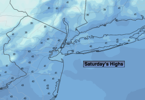
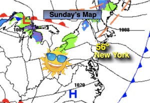
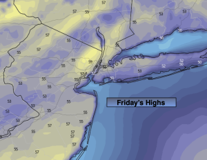
Our tolerable  January  conditions will continue for the second half of the weekend. Finally, the sun will dominate today. Clouds will roll in later in the afternoon. Readings will be as close to average in many, many days. The average high is in the upper 30s.

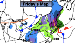
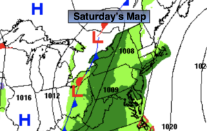
A weak disturbance will move into the area tonight with the snow showers inland. At the coast and along the urban corridor a mix or light rain is likely. A dusting to a coating of snow is possible inland by morning, especially on colder surfaces.

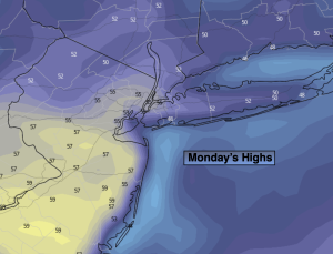
Early morning flakes and showers Monday will give way to partly sunny skies. Readings will still be above average.

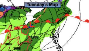
High pressure will move in from the West on Tuesday and Wednesday bringing with it abundant sunshine and still above average readings.

The deep cold air will not make it down into our area as long as the polar jet stream remains in Canada. The pacific jet stream continue to scream. These are contributing factors to a snowless Winter, so far…

Stay tuned.

Keep it here for a no hype, no nonsense forecast.

Sunday:

Sun to clouds. Highs around 40º.  Northwest to South winds under 5mph.

Tonight:

Snow showers inland. A light mix or rain at the coast and to the South. Lows in the mid 30s in the City, the upper 20s to around freezing inland. Light winds.

Monday:

A few morning flakes or showers, otherwise clouds giving way to sun. Highs in the lower to mid 40s.

Tuesday:

Sunny. Highs in the mid to upper 40s.

Wednesday:

Sunny. Highs in the lower to mid 40s.

Thursday:

Mostly sunny. Highs in the lower to mid 40s.

Clouds, Some Sun Saturday…


Synopsis:

The upcoming weekend looks decent for January as high pressure moves in. More clouds than sun is expected today, with more sun than clouds on Sunday. Yep, you guessed it readings will be above average, by a couple degrees anyway. The average high is in the upper 30s.

A weak disturbance will move through Sunday night with the possibility of snow showers.

Any clouds and early flakes Monday should give way to partly sunny skies. Readings will still be tolerable.

High pressure will dominate on Tuesday and Wednesday bringing with it abundant sunshine and still above average readings.

The deep cold air will not make it down into our area as long as the polar jet stream remains in Canada. The pacific jet stream continue to scream. These are contributing factors to a snowless Winter, so far…

Stay tuned.

Keep it here for a no hype, no nonsense forecast.

Saturday:

Clouds, some sun. Highs in the mid 40s. Northwest winds at 8-15mph.

Tonight:

Mostly clear. Lows around freezing in the City, the 20s inland. Northwest winds at 5-10mph.

Sunday:

Sun to clouds. Highs around 40º.

Monday:

A few morning flakes, otherwise clouds giving way to sun. Highs in the lower to mid 40s.

Tuesday:

Sunny. Highs in the mid to upper 40s.

Wednesday:

Sunny. Highs in the lower to mid 40s.

Scattered Showers Today. Clouds Rule. Cooler…


Synopsis:

A weak low just East of our region will strengthen slightly as it moves off the New England coast. Scattered showers are likely today. There will be long periods of dry times. The cooldown will continue.

The upcoming weekend looks decent still for January as high pressure moves in. Yep, you guessed it readings will be above average, by a couple degrees anyway.

A weak disturbance will move through Sunday night with the possibility of snow showers.

Any clouds Monday should give way to partly sunny skies. Readings will still be tolerable.

High pressure will dominate on Tuesday bringing with it abundant sunshine and still above average readings.

The deep cold air will not make it down into our area as long as the polar jet stream remains in Canada.

Stay tuned.

Keep it here for a no hype, no nonsense forecast.

Friday:

Scattered showers. Cooler. Highs in  the mid 40s. Northwest winds at 5-10mph.

Tonight:

Becoming partly cloudy. Lows in the mid 30s in the City, around freezing inland. Northwest winds at 5-10mph.

Saturday:

Sun and clouds. Highs in the mid 40s.

Sunday:

Sun to clouds. Highs around 40º.

Monday:

Clouds to sun. Highs in the lower to mid 40s.

Tuesday:

Sunny. Highs in the upper 40s.

Clouds & Sun Thursday. Still Mild…


Synopsis

We’ll cool off some today but still be well above average with temperatures. The average is in the upper 30s to around 40º. A mix of sun and clouds is expected.

Tonight and  Friday a weak low over our region and strengthen slightly as it moves off the New England coast. Scattered showers are possible tonight with a chance of spotty showers on Friday. A mix of clouds and sun is expected. The cooldown will continue.

The upcoming weekend looks decent still for January as high pressure moves in. Yep, you guessed it readings will be above average, by a couple degrees anyway.

A weak disturbance will move through Sunday night with the possibility of a few snow showers.

Any clouds Monday should give way to partly sunny skies. Readings will still be tolerable.

Stay tuned.

Keep it here for a no hype, no nonsense forecast.

Thursday:

Sun and clouds. Still mild. Highs in the mid 50s. Northeast winds at 5mph.

Tonight:

Scattered showers. Lows around 40º in the City, the 30s inland. East to Northeast winds at 5mph.

Friday:

Spot shower, otherwise clouds and sun. Highs in  the mid to upper 40s.

Saturday:

Sun and clouds. Highs in the mid 40s.

Sunday:

Sun to clouds. Highs around 40º.

Monday:

Clouds to sun. Highs in the lower to mid 40s.

Some AM Sun to Clouds. Very Warm. Late Day Rain…


Synopsis

Our Spring feel will continue through Thursday as the jet stream will remain well to the North keeping the cold air at bay. Temperatures through this period will be ten to twenty degrees above the average high of around 40º. In fact, on today most areas will experience readings in the 60s- balmy for sure! We’ll be flirting with the record high of 66º at Central Park.

Today, ahead of the next approaching low from the South any morning fog will burn off. The sun should shine for a tine this morning. Clouds will rapidly move in thereafter. Rain is not expected until mid-afternoon. It will feel like a day out of late April with readings approaching the mid 60s in many areas.

The low will move through tonight with rain ending before midnight.

We’ll cool off on Thursday but still be well above average with temperatures. More clouds than sun is expected.

On Friday, a weak low will develop off the coast. If enough moisture is thrown back to the coast showers are possible. The trend toward cooler will continue.

The upcoming weekend looks decent still for January as high pressure moves in. Yep, you guessed it readings will be above average, by a couple degrees anyway.

Stay tuned.

Keep it here for a no hype, no nonsense forecast.

Wednesday:

Patchy morning fog, otherwise mostly cloudy. Rain developing by mid-afternoon. Warm. Highs in  the mid 60s. Southwest to South winds at 5mph.

Tonight:

Early rain, otherwise remaining mostly cloudy. Mild. Lows in the 40s throughout. Light and variable winds.

Thursday:

Mostly cloudy. Cooler. Highs in the lower 50s.

Friday:

Spot shower, otherwise mostly cloudy. Highs in  the mid to upper 40s.

Saturday:

Sun and clouds. Highs in the mid 40s.

Sunday:

Sun and clouds. Highs in the mid 40s.

Areas of Fog Tuesday AM. On & Off Rain. Mild…


Synopsis

Our Spring feel will continue through midweek as the jet stream will remain well to the North keeping the cold air at bay. Temperatures through this period will be ten to twenty degrees above the average high of around 40º. In fact, on Wednesday most areas will experience readings in the lower 60s- balmy for sure!

Two areas of low pressure will affect the region through midweek with grey and damp conditions expected. System number one will move out of the Ohio Valley and toward the region today. Areas of fog will be with us with an approaching warm front, especially in the morning. The steadiest rain will be for the Northern half of the NYC tri-state area with the Northward moving front. This steady rain should move in during the afternoon.

The second system on Wednesday will follow a familiar track. Scattered showers are possible just about anytime. It will not be a washout.

A cool front will move through on Thursday with possible morning showers. We should dry out by afternoon. We’ll cool off but still be well above average.

On Friday, a weak low will develop off the coast. If enough moisture is thrown back to the coast showers are possible. The trend toward cooler will begin.

Saturday is the top pick of the next five with a mix of sun and clouds and still slightly above average readings.

Stay tuned.

Keep it here for a no hype, no nonsense forecast.

Tuesday:

Morning fog and drizzle with on and off rain or showers developing. Southern NJ may remain mainly dry. Highs in the mid 50s. East to South winds at 5-10mph.

Tonight:

Evening rain otherwise a slight chance of a shower overnight. Mild. Lows in the lower to mid 50s along the coast, the 40s to lower 50s inland. Southwest winds at 5-10mph.

Wednesday:

Cloudy with scattered showers. Much of the day will be rain-free. Balmy. Highs in  the lower 60s.

Thursday:

Morning showers possible. If we’re lucky we’ll get to see some afternoon sun. Cooler. Highs around 50º.

Friday:

Chance of showers. Highs in  the mid 40s.

Saturday:

Sun and clouds. Highs in the mid 40s.

Sun & Clouds. Mild…


Synopsis

Happy New Year!

Our Spring feel will continue through midweek as the jet stream will remains well to the North keeping the cold air at bay. Temperatures through this period will be ten to twenty degrees above the average high of around 40º. In fact, on Wednesday most areas will experience readings in the lower 60s!

High pressure dominate the Eastern seaboard through today with a mix of sun and clouds.

Low pressure will move out of the Ohio Valley and toward the region Tuesday into Wednesday. It’ll be grey with  on and off rain or showers just about anytime. It will not be a complete washout.

A cool front will move through on Thursday with morning showers. We should dry out by afternoon. We’ll cool off but still be a few degrees above average under a mix of clouds and sun.

On Friday, a weak low will develop off the coast. If enough moisture is thrown back to the coast rain or snow showers are possible. The trend toward colder will begin.

Stay tuned.

Keep it here for a no hype, no nonsense forecast.

Monday:

Sun and clouds. Mild. Highs in the lower to mid 50s. West to Northwest winds at 5mph.

Tonight:

Cloudy with areas of fog. Slight chance of a shower. Lows in the 40s throughout. Light Southwest to Southeast winds.

Tuesday:

Cloudy with on and off rain or showers. Highs in the mid 50s.

Wednesday:

Cloudy with on and off rain or showers. Balmy. Highs in  the lower 60s.

Thursday:

Morning showers. Some afternoon sun possible. Cooler. Highs in the upper 40s.

Friday:

Chance of rain and or snow showers. Highs in  the lower 40s.

Sun Returns for the New Year! Mild…


Synopsis

Happy New Year!

The sun will return for the start of the New Year. High pressure over the Southeast will strengthen and build along the Eastern seaboard through Monday. Today and tomorrow will be mainly sunny and mild.

Low pressure will move out of the Ohio Valley and toward the region Tuesday into Wednesday. Mainly cloudy skies are expected with the chance of showers just about anytime. It will not be a complete washout.

The jet stream through midweek will continue to be the atmospheric highway for a unseasonably mild time. Temperatures through this period will be ten to twenty degrees above the average high of around 40º. In fact, Wednesday most areas will experience readings in the 60s!

A cool front will move through on Thursday. We’ll cool off but still be a few degrees above average under a mix of clouds and sun.

Stay tuned.

Keep it here for a no hype, no nonsense forecast.

New Year’s Day:

Mostly sunny, breezy and mild. Highs in the mid 50s. Northwest winds at 10-20mph.

Tonight:

Mostly clear. Lows in the lower 40s along the urban corridor, the 30s inland. West Winds diminishing to 5mph.

Monday:

Mostly sunny. Highs in the lower 50s.

Tuesday:

Mostly cloudy. Scattered showers. Very mild. Highs in the mid to upper 50s.

Wednesday:

Mostly cloudy. Scattered showers. Balmy. Highs in  the lower 60s.

Thursday:

Sun and clouds. Cooler. Highs in  the mid 40s.

Sct’d Showers. More Widespread Toward Evening. Mild…


Synopsis

Scattered showers and mild temperatures will be the story for the last day of 2022. Areas of fog will add to the gloom, especially in the morning. Low pressure will move out of the Southern Appalachians. The showers will become more widespread toward evening. It’s a mild storm track. At the stroke of midnight there will be areas of rain and it’ll be very mild with readings around 50º!

The storm will move out of the region for New Year’s Day but the mild temperatures will stick around for the beginning of 2023 as all the cold air is locked up in Canada. It’ll be a mainly sunny for Monday, January 2nd.

Low pressure will move out of the Ohio Valley and toward the region later Tuesday and into Wednesday. Clouds and sun and a few showers later in the day are in the forecast for Tuesday. Periods of rain and balmy conditions are expected for Wednesday.

Temperatures through the the next five days will be ten to twenty degrees above the average high of around 40º.

Stay tuned.

Keep it here for a no hype, no nonsense forecast.

New Year’s Eve:

Cloudy with scattered showers and areas of morning fog. Mild. Highs in the mid 50s. East to Southeast winds at 5mph.

Tonight:

Areas of rain. Mild. Lows in the upper 40s along the urban corridor to the upper 30s and 40s inland. Winds becoming West at 5-10mph.

New Year’s Day:

Mostly sunny. Still mild. Highs in the mid 50s.

Monday:

Sunny. Highs around 50º.

Tuesday:

Clouds and sun. Chance of afternoon showers. Highs in the mid to upper 50s.

Wednesday:

Periods of rain. Balmy. Highs around 60º.

Late March Feel Friday. Abundant Sunshine…


Synopsis

High pressure off the Eastern seaboard will dominate our area today. A Southwest flow will result in a continued warming trend. Our trend of above average temperatures will continue (average temps are around 40º for highs) and readings will be at least ten degrees higher than normal for the rest of the five day period. Enjoy the break from the cold while it lasts!

The next chance of showers will come Saturday, New Year’s Eve. Low pressure will move out of the Southern Appalachians. Showers should develop by afternoon. It’s a mild storm track, equating to no snow. At the stroke of midnight rain is expected and it’ll be very mild with readings around 50º!

The storm will move out of the region for New Year’s Day but the mild temperatures will stick around for the beginning of 2023 as all the cold air is locked up in Canada. It’ll be a mainly sunny through the first few days in January. Not feeling like the season whatsoever.

Stay tuned.

Keep it here for a no hype, no nonsense forecast.

Friday:

Mostly sunny. Mild. Highs in the mid 50s. Southwest winds at 5-10mph.

Tonight:

Becoming mostly cloudy late. Milder than the average high for the date! Lows in the upper 40s along the urban corridor to the upper 30s and 40s inland. Light Southwest winds.

New Year’s Eve:

Mostly cloudy. Mild. Chance of afternoon rain. Highs in the mid 50s..

New Year’s Day:

Mostly sunny. Still mild. Highs in the lower to mid 50s.

Monday:

Sunny. Highs around 50º.

Tuesday:

Sunny. Highs in the mid 50s.