Intermittent Snow Today. Windy…

Synopsis:

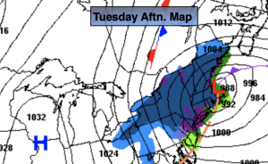
An intensifying offshore storm will continue to affect the region through today. The lack of Arctic high pressure will be one of the several reasons this will not be a significant snow for the Southern 2/3rd’s of the region.

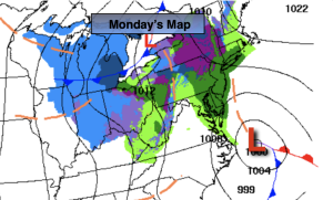
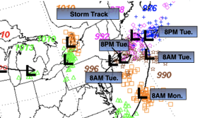
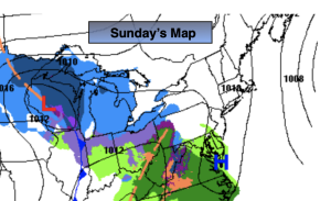
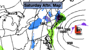
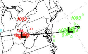
The upper levels (jet stream level) will have a deepening cutoff low that will move from Southern NJ this morning to East of Long Island by this evening. . This will do two things: Strengthen the first surface low and also bring down colder air from the upper levels of the atmosphere. The second low over Eastern low over Eastern Long Island will consolidate with the main storm. The ocean storm will move onshore over Eastern Massachusetts and do a loop then move back over the Atlantic.

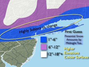
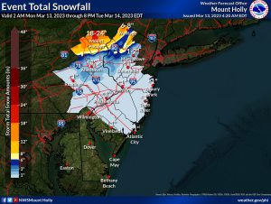
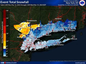
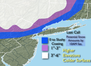
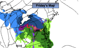
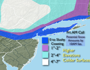
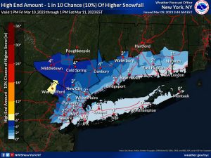
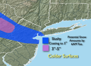
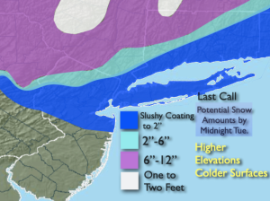
There will be intermittent snow throughout today from all of these systems. Our region is on the Southwest side of the snow bands- the backside of the storm if you will. Since the storm will be consolidating and slowing down the on and off snow will last into this evening. Some of it will come down light at other times it may come down at a fairly good clip.  These total snow amounts will be elevation driven. If you live in a county with drastic changes in elevation within a couple of miles that will result in the difference of a couple of inches of snow. Pavement and concrete surfaces will have a significantly lower slushier amount or none at all.

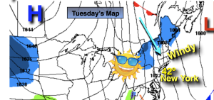
The winds will also pick up out of the Northwest and gust to over 40mph at times.

Any evening snow will taper off and end. Skies will become partly cloudy overnight and the winds will be strong.

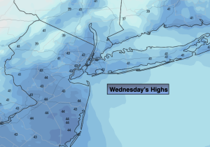
Wednesday the sun will dominate and winds will continue to be busy as the storm moves farther out to sea.

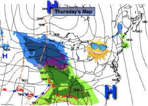
Thursday will be more tranquil, bright and mild as high pressure works in.

The luck of the Irish will be around on St. Patrick’s. A mix of sun and clouds are expected with Springtime readings.

A few morning showers are expected on Saturday, otherwise the sun will return with above average readings.

Stay tuned. Keep it here for a no nonsense, no hype forecast.

Tuesday:

On and off snow (rain out East, changing to snow) deepening on location. Windy. Highs in the 30s. West to Northwest winds at 15-30mph with gusts to 40mph.

Tonight:

Evening areas of snow ending. Mostly cloudy. Windy. Lows around freezing along the urban corridor, the upper 20s well inland. Northwest winds at 15-30mph with gusts to 40mph.

Wednesday:

Partly sunny. Windy. Highs in the mid 40s.

Thursday:

Sunny. Milder. Highs in the mid 50s.

Friday:

Partly sunny. Mild. Highs in the upper 50s.

Saturday:

Morning showers, afternoon sun. Highs in the mid 50s.

Rain Monday. Well North Some Mixing…


Synopsis:

The highly advertised storm is on the map for today and Tuesday as low pressure develops off the coast of Virginia. The potential track of the storm is above. The latest guidance has the storm a bit farther to the East. The first part of the storm is straight forward. There isn’t a cold high to supply the cold air for the start of the event. For this reason, rain will develop and not snow for today for much of the region. Well to the North wet snow or a mix is likely.

Now, this is where the fun part begins (for meteorologists anyway) for Monday night and Tuesday. The upper levels (jet stream level) will have a deepening cutoff low that will slide Southeast from the Great Lakes to NJ. At the same time surface low pressure will strengthen rapidly off the Virginia coast and move to just to the East of the classic bench mark of 40º North Latitude, 70º West Longitude, South East of Montauk Point Long Island. All the models have the storm coming to a halt then doing a loop near Cape Cod.

A second low looks to develop near the NYC vicinity and then traverse East across Long Island with the upper level cutoff. Depending on where this exactly happens will determine the Western extent of the heavy snow band that will accompany the backside of the storm into NJ and NY State. This is known as the deformation zone. The area of heavy snow. Where the two enhanced areas of heavy snow set up to the the North and West of both surfaces storms will mean all the difference in snow amounts. A full fledge snowstorm is likely where this bands sit. The latest models have moved the sharp cutoff of precipitation to the Northeast. This would most likely result in not much snow accumulation in the City, Long Island and much of the stretch of the 1-95 corridor through NJ. Potential snow amounts above. The last two maps is what JMW is leaning towards.

In summary, the potential has increased for a snowstorm North of NYC. It has become clearer that the sharp cutoff of heavy precipitation will be moved 20 to 30 miles to the Northeast drastically keeping snow amounts quite low. Winds will increase Tuesday as the two storms combine and bomb near Cape Cod.

Wednesday will be bright but windy. Thursday the sun will dominate and winds will abate.

St. Patrick’s day will  be very mild under a mix of sun and clouds.

Stay tuned. Keep it here for a no nonsense, no hype forecast.

Monday:

Rain. A mix well North. Highs in the mid 40s. East winds at 8-12mph.

Tonight:

Rain for the I-95 corridor. Mix to snow well inland. Lows around in the mid 30s along the urban corridor, near freezing well inland. East to North winds at 10-20mph.

Tuesday:

Heavy snow Northwest. Rain, mix to some snow at coast.  Windy. Highs 30º-35º.

Wednesday:

Partly sunny. Windy. Highs around 40º.

Thursday:

Sunny. Milder. Highs around 50º.

Friday:

Partly sunny. Mild. Highs in the mid to upper 50s.

Rain Monday. Well North Some Mixing…

Synopsis:

The highly advertised storm is on the map for Monday and Tuesday as low pressure develops off the coast of Virginia. The potential track of the storm is above. This is a classic text book track for a heavy snowfall for our area, if all the ingredients are there. We have to remember this is mid March and many ingredients need to be perfect for a snowstorm here. The first part of the storm is straight forward. There isn’t a cold high to supply the cold air for the start of the event. For this reason, rain will develop and not snow on Monday for much of the region. Well to the North wet snow or a mix is likely.

Now, this is where the fun part begins (for meteorologists anyway) for Monday night and Tuesday. The upper levels (jet stream level) will have a deepening cutoff low that will slide Southeast from the Great Lakes to NJ. At the same time surface low pressure will strengthen rapidly off the Virginia coast and move to the classic bench mark of 40º North Latitude, 70º West Longitude, South East of Montauk Point Long Island. All the models have the storm coming to a halt then doing a loop over Cape Cod.

A new development in the evolving situation-a second low looks to develop near the NYC vicinity and then traverse East across Long Island with the upper level cutoff. Depending on where this exactly happens will determine the Western extent of the heavy snow band that will accompany the backside of the storm into NJ and NY State. This is known as the deformation zone. The area of heavy snow. Where the two enhanced areas of heavy snow set up to the the North and West of both surfaces storms will mean all the difference in snow amounts. A full fledge snowstorm is likely where this bands sit. The potential snow amounts-First Guess are above. These amounts are a generalization at this time. A low confidence snow prediction continues for the circled area. It could be MUCH higher.

In summary, the potential has increased for a snowstorm North of NYC where the Winter Storm Watches and Warning are up. A few big questions still need to be answered for immediate NYC vicinity. Winds will increase Tuesday as the two storms combine and bomb near Cape Cod.

Wednesday will be bright but windy. Thursday the sun will dominate and winds will abate.

St. Patrick’s day will  be very mild under a mix of sun and clouds.

Stay tuned. Keep it here for a no nonsense, no hype forecast.

Tonight:

Cloudy. A bit of light rain possible late. Lows around in the mid 30s along the urban corridor, near freezing well inland. Southeast to East winds at 5mph.

Monday:

Rain. A mix well North. Highs in the mid 40s. East winds at 8-12mph.

Tuesday:

Potential of snow. Heavy Northwest. Rain, mix to snow at coast.  Windy. Highs 30º-35º.

Wednesday:

Partly sunny. Windy. Highs around 40º.

Thursday:

Sunny. Milder. Highs around 50º.

Friday:

Partly sunny. Mild. Highs in the mid to upper 50s.

Sun Returns for Sunday. Clocks Ahead One Hour Tonight…

Synopsis:

Tonight skies will become partly cloudy. We “Spring Ahead” tonight. Eastern Standard Time Ends, Daylight Saving Time begins at 2am. Don’t forget to set your clocks ahead one hour before hitting the hay. It’s also a reminder to change the batteries in your smoke and carbon monoxide detectors.

Sunday definitely will be the better half of the weekend with brighter skies and seasonable readings as high pressure influences the region. It will be a brief break, unfortunately.

The next storm is on the map for Monday and Tuesday as low pressure develops off the coast. The potential track of the storm is above. This is a classic text book track for a heavy snowfall for our area, if all the ingredients are there. We have to remember this is mid March and many ingredients need to be perfect for a snowstorm here. The first part of the storm is straight forward. There isn’t a cold high to supply the cold air for the start of the event. For this reason, rain will develop and not snow on Monday for much of the region. Well to the North wet snow or a mix is likely.

Now, this is where the fun part begins (for meteorologists anyway) for Monday night and Tuesday. The upper levels (jet stream level) will have a deepening cutoff low that will slide Southeast from the Great Lakes. At the same time surface low pressure will strengthen rapidly off the Virginia coast and move to the classic bench mark of 40º North Latitude, 70º West Longitude, South East of Montauk Point Long Island. All the models have the storm coming to a halt then doing a loop over Cape Cod or East of Long Island. Depending on where this exactly happens will determine the Western extent of the heavy snow band that will accompany the backside of the storm. This is known as the deformation zone. The area of heavy snow. As of this writing the potential for this band to reach the lower Hudson Valley and parts of CT is there for late Monday night into Tuesday. Meaning a full fledge snowstorm is possible here. Farther South into the immediate NYC vicinity, Long Island and Northern NJ it’s a big question mark at this time. Some snow is quite possible on Tuesday (rain going over to snow over the City and parts of Long Island during the morning with an accumulation. Amounts also may be cut down because of a warm fetch farther East on the Island and parts of CT. South and West of 287 in NJ may also have much lighter amounts because they maybe too far from the heavier snows. Winds will be strong with the storm.

In summary, the potential has increased for a snowstorm North of NYC where the Winter Storm Watch is up. Many questions still need to be answered.

Wednesday will be bright but windy. Thursday the sun will dominate and winds will abate.

Stay tuned. Keep it here for a no nonsense, no hype forecast.

Tonight:

Becoming partly cloudy. Lows around in the mid 30s along the urban corridor, the upper 20s inland. North winds diminishing to 5-10mph.

Sunday:

Mostly sunny and breezy. Late day clouds. Highs in the mid 40s. Northeast to Southeast winds at 5mph.

Monday:

Rain developing, a mix well North. Highs in the mid 40s.

Tuesday:

Potential of snow. Heavy North. Rain, mix to snow at coast.  Windy. Highs 30º-35º.

Wednesday:

Partly sunny. Windy. Highs around 40º.

Thursday:

Sunny. Mild Highs around 50º.

Rain/Mix/Snow Tapers Off Later This AM…


Synopsis:

Low pressure will continue to deepen off the NJ coast today. Areas of rain and snow will continue this morning and taper off toward midday. The accumulations that occurred were on the lighter side of the potential amounts above. The atmosphere as expected was just too warm elsewhere. Also as stated this was an elevation driven accumulation.

Tonight skies will become partly cloudy.

Sunday definitely will be the better half of the weekend with brighter skies and seasonable readings as high pressure influences the region. It will be a brief break, unfortunately.

The next potential storm is on the map for Monday and Tuesday as low pressure develops off the coast. The track and all the typical questions still need to be answered. This system will be a stronger low that is affecting the region now, but where will those affects be felt? Rain will develop for most areas during the morning Monday. The rain could possibly change to snow Monday night as the storm bombs out off the coast. Again, this is a potential. Much can change in the next few days. I just want you to be aware of the possible scenario. If the storm is too far off the coast lighter precipitation will fall.

Tuesday will feature the intense storm somewhere in the Cape Cod vicinity with some potential morning precipitation giving way to late day sun and gusty winds.

Winds will be busy under a mainly sunny sky on Wednesday behind the departing storm.

Stay tuned. Keep it here for a no nonsense, no hype forecast.

Saturday:

AM Snow or rain depending on location. Remaining mainly cloudy during the afternoon. Breezy. Highs in the upper 30s and lower 40s. North/Northeast winds at 10-20mph with gusts to 30mph.

Tonight:

Partly cloudy. Lows around in the mid 30s along the urban corridor, the upper 20s inland. North winds diminishing to 5-10mph.

Sunday:

Mostly sunny and breezy. Highs in the mid 40s.

Monday:

Potential for rain, a mix well inland. Highs in the mid 40s.

Tuesday :

Potential morning mix or snow. Some PM sun. Windy. Highs around 40º.

Wednesday :

Partly sunny. Windy. Highs around 40º.

Thickening Clouds Friday. Late Aftn. Rain. Mix/Snow NW…


Synopsis:

Thickening clouds will be the forerunner of the developing low pressure that will throw late day rain our way during this afternoon. Wet snow will fall North and West. The starting time looks to be any time after Noon West to East.

Upper level energy will be diving out of the Great Lakes and spawning a coastal low. The low will track to the South of the region and give the area a round of precipitation this afternoon and ending during the late morning hours on Saturday. The potential is for rain or a mix for coastal areas, possibly ending as some snow. Farther inland a mix or snow is likely with a likely accumulation. Above is the Friday AM Call potential amounts by late Saturday morning. This will be an elevation accumulation. If you reside in a county that has varying elevations, that may mean the difference of several inches of snow within a few miles. Take these amounts as a generalization. Also, the colder surfaces will have the final totals. Pavement and concrete will have a much lower slushier amount. These snow bands will most likely change as new computer guidance comes in.

Sunday definitely will be the better half of the weekend with brighter skies and seasonable readings as high pressure influences the region. It will be a brief break, unfortunately.

The next potential storm is on the map for Monday as low pressure develops along or off the coast. The track and all the typical questions still need to be answered. This system will be a stronger low that will affect the region Friday Night and Saturday. Rain will develop for most areas during the morning. The rain could possibly change to snow Monday night as the storm bombs out off the coast. Again, this is a potential. Much can change in the next few days. I just want you to be aware of the possible scenario. If the storm is too far off the coast lighter precipitation will fall.

Tuesday will feature the departing storm with some morning precipitation giving way to late day sun.

March is roaring now.

Stay tuned. Keep it here for a no nonsense, no hype forecast.

Friday:

Thickening clouds. Rain developing during the afternoon. Snow likely North and West. Highs in the mid 40s then falling late day. Northeast to Southeast winds at 5mph.

Tonight:

Rain, mix or snow depending on location. Lows around in the lower to mid 30s along the urban corridor, the upper 20s inland. East to North/Northeast winds at 5-15mph.

Saturday:

AM Snow. A mix likely going over to snow before ending at the coast. Highs in the upper 30s and lower 40s.

Sunday:

Mostly sunny and breezy. Highs in the mid 40s.

Monday:

Potential for rain, a mix well inland. Highs in the mid 40s.

Tuesday :

Potential morning mix or snow. Some PM sun. Highs around 40º.

Better Feel Thursday. Winds Abate. Seasonable…


Synopsis:

Mainly sunny skies are expected today with winds abating as high pressure settles over the East coast. Highs will be near average which is the mid to upper 40s.

On Friday any sun will give way to clouds. Developing low pressure will throw late day rain our way. Wet snow will fall North and West.

JMW continues to gain confidence in the evolution of the next storm for Friday evening into Saturday. Upper level energy will be diving out of the Great Lakes and spawning a coastal low. The models are coming into better agreement. The low will track to the South of the region and give the area a round of precipitation starting Friday evening and ending during the late morning hours on Saturday. The potential is for rain or a mix for coastal areas, possibly ending as some snow. Farther inland a mix or snow is likely with a likely accumulation. Above are the first guess maps that I used from the National Weather Service. I mostly agree with this at this time. I will update this later today with my own graphic. The precipitation will end Saturday and skies may break for some sun later in the day.

Sunday definitely will be the better half of the weekend with brighter skies and seasonable readings as high pressure influences the region. It will be a brief break, unfortunately.

The next potential storm is on the map for Monday as low pressure develops along or off the coast. The track and all the typical questions still need to be answered. This system will be a stronger low that will affect the region Friday Night and Saturday. March is roaring now.

Stay tuned. Keep it here for a no nonsense, no hype forecast.

Thursday:

Mostly sunny. Highs in the mid to upper 40s. Northwest winds diminishing to 5-10mph by afternoon.

Tonight:

Partly cloudy. Lows around in the lower to mid 30s along the urban corridor, the upper 20s inland. North winds at 5-15mph.

Friday:

Sun to late clouds. Chance of rain by late day.  Snow likely North and West. Highs in the mid 40s then falling late day.

Saturday:

AM Snow. A mix likely going over to snow before ending at the coast. Highs in the upper 30s and lower 40s.

Sunday:

Mostly sunny and breezy. Highs in the mid 40s.

Monday:

Potential for rain or snow. Highs around 40º.

Bright but Brisk Wednesday…


Synopsis:

The wind will stay busy through today due to the difference in strong weather systems. Intense low pressure be draped over the North Atlantic with strong high pressure centered over central Canada. Mainly sunny skies are expected today and Thursday with winds abating by later Thursday. Highs will range near average-the mid 40s.

On Friday winds will relax high pressure noses down from Canada. Any sun will give way to clouds.

JMW is gaining more confidence in the evolution of the next storm for Friday evening into Saturday. Upper level energy will be diving out of the Great Lakes and spawning a coastal low. The models are starting to come into agreement. The low will track to the South of the region and give the area a round of precipitation starting Friday evening and ending during the morning on Saturday. The potential is for rain or a mix for coastal areas, possibly ending as some snow. Farther inland a mix or snow is likely with a likely accumulation. A few inches North and West is the first guess at this time. The precipitation will end Saturday and skies may break for some sun later in the day.

Sunday definitely will be the better half of the weekend with brighter skies and seasonable readings as high pressure influences the region.

Stay tuned. Keep it here for a no nonsense, no hype forecast.

Wednesday:

Mostly sunny. Windy and seasonable. Highs in the mid 40s. Northwest winds qt 15-25mph with gusts to 30mph.

Tonight:

Partly cloudy, breezy and cold. Lows around freezing along the urban corridor, the upper 20s inland. Northwest winds at 10-20mph.

Thursday:

Mostly sunny. Highs in the mid to upper 40s.

Friday:

Sun to late clouds. Chance of rain or a mix by evening. Highs in the mid 40s.

Saturday:

Potential for some snow. A mix likely going over to snow before ending at the coast. Highs in the upper 30s and lower 40s.

Sunday:

Mostly sunny and breezy. Highs in the mid 40s.

Clouds & Sun. Becoming Windy…


Synopsis:

The sun will return today with readings around seasonable levels of the mid 40s. Winds will increase and become quite gusty. The wind will actually be brisk from the North due to the difference in strong weather systems. Intense low pressure be draped over the North Atlantic with strong high pressure centered over central Canada. A mix of sun and clouds is expected with highs around seasonable levels.

On Friday winds will relax high pressure noses down from Canada. It’ll be a fine clouds to the workweek.

Looking ahead, there is a potential system to watch as upper level energy will be diving out of the Great Lakes and most likely spawning a coastal low. Where this low forms, how strong it is and how rapidly it moves are questions that won’t be answered for a few days. The outcome of this scenario will determine our forecast for Saturday. As of this writing there is a possibility of rain or snow.

Stay tuned. Keep it here for a no nonsense, no hype forecast.

Tuesday:

Becoming partly sunny and windy.  Highs in the lower to mid 40s. Northwest winds increasing to 15-25mph with gusts to 35mph.

Tonight:

Partly cloudy, windy and cold. Lows in the upper 20s to around 30º along the urban corridor, the 20s inland. Northwest winds at 15-25 with gusts to 35mp. .

Wednesday:

Mostly sunny. Breezy and seasonable. Highs in the mid 40s.

Thursday:

Mostly sunny. Breezy. Highs in the mid to upper 40s.

Friday:

Mostly sunny. Highs in the mid to upper 40s.

Saturday:

Potential for some rain or snow. Highs in the upper 30s and lower 40s.

Quick Hitting Snow for Some Overnight. Sun Returns Tuesday…


Synopsis:

March has quickly developed a weather event up his or her sleeve. Low pressure pressure will move rapidly from Ohio to off the Delaware coast tonight. The small system now looks to carry a bit of a bunch as it strengthens (2nd map above) as it moves just South of the area. There will be a narrow band of snow or mixed precipitation from the Poconos to the Central NJ coast. The timing is toward midnight to before sunrise-a quick hitter. In areas where the snow is the steadiest and temperatures are around or below freezing, a coating to three inches on colder surfaces is possible by sunrise. The streets, pavement and sidewalks will have retained the heating of the day and will have a lower accumulation. Where this narrow band sets up, how heavy the precipitation, how quickly it moves through and how cold your area is will make all the difference in amounts received. These bands are not etched in stone. If you live within 10 miles of a band your amounts could go either way. Don’t concentrate on your exact location, but the general vicinity.

The sun will return Tuesday later in the morning with readings around seasonable levels of the mid 40s.

Wednesday and Thursday will feature a brisk North wind created by the difference in strong weather systems. Intense low pressure be draped over the North Atlantic with strong high pressure centered over central Canada. A mix of sun and clouds is expected with highs around seasonable levels.

On Friday winds will relax high pressure noses down from Canada. It’ll be a fine clouds to the workweek.

Looking ahead, there is a potential system to watch as upper level energy will be diving out of the Great Lakes and most likely spawning a coastal low. Where this low forms, how strong it is and how rapidly it moves are questions that won’t be answered for a few days. The outcome of this scenario will determine our forecast for Saturday. As of this writing there is a possibility of rain or snow. There is a lot of chatter from non meteorologists putting false information in the publics ear. You know where to turn, to find a no hype, no nonsense forecast.

Stay tuned.

Tonight:

Thickening clouds. An area of snow or mixed rain and snow over parts of the region. Lows in the mid 30s along the urban corridor, the upper 20s to around freezing inland. Northwest winds at 5-10mph.

Tuesday:

Becoming partly sunny and breezy.  Highs in the lower to mid 40s. Northwest winds increasing to 15-25mph with gusts to 30mph.

Wednesday:

Mostly sunny. Breezy and seasonable. Highs in the mid 40s.

Thursday:

Mostly sunny. Breezy. Highs in the mid to upper 40s.

Friday:

Mostly sunny. Highs in the mid to upper 40s.

Saturday:

Potential for some rain or snow. Highs in the upper 30s and lower 40s.