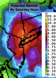
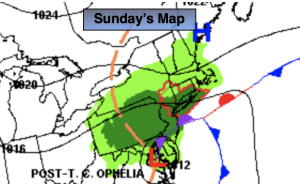
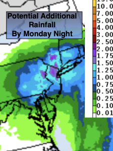
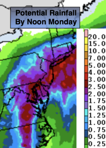
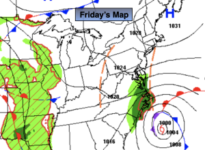
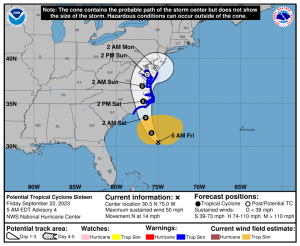
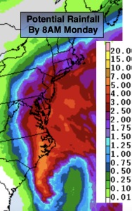
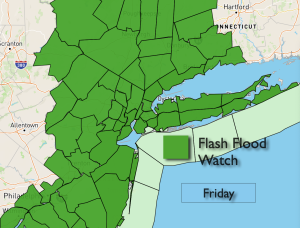
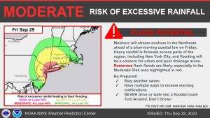
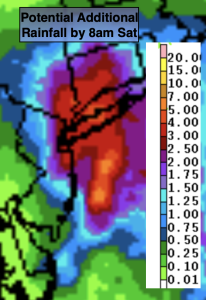
Cooler Breeze Wednesday…

Synopsis:

Cooler readings are expected for the rest of the week as Canadian high pressure takes control. The sun will dominate. Readings will be several degrees below the average high of the lower 70s.

The next threat of showers will come Saturday. The combination of weak offshore low pressure and an approaching cool front will be responsible for the damp potential. The shower threat is a low one but remains in the forecast.

Sunday will be the better half of the weekend with abundant sunshine and mild readings as high pressure takes the stage.

Keep it here for a no nonsense, no hype forecast.

Wednesday:

Sunny, breezy and cooler. Highs in the mid 60s. Northwest winds at 15-25mph.

Tonight:

Clear and quite chilly. Lows in the mid 40s along the urban corridor, near 30º well inland with a freeze possible. Northwest winds at 10-20mph early then diminishing to 5mph.

Thursday:

Sunny. Highs in the mid 60s.

Friday:

Mostly sunny. Highs around 70º.

Saturday:

Mostly cloudy. Chance of showers. Highs around 70º.

Sunday:

Sunny and mild. Highs in the mid to upper 70s.

Warm, Sunny Tuesday…

Synopsis:

Temperatures will pop on Tuesday ahead of a cool front under a mostly sunny sky. Many areas will be flirting with 80º.

Cooler readings are expected for the rest of the week as Canadian high pressure takes control. The sun will dominate. Readings will be several degrees below the average high of the lower 70s.

The next threat of showers will come Saturday. The combination of weak offshore low pressure and an approaching cool front will be responsible for the damp potential. Confidence in Saturday’s forecast at this time is low. Stay tuned.

Keep it here for a no nonsense, no hype forecast.

Tuesday:

Sunny. Warmer. Highs around 80º. West to Southwest winds at 10-20mph.

Tonight:

Mostly clear. Lows in the mid 50s along the urban corridor, the 40s inland. West to Northwest wind at 10-20mph.

Wednesday:

Sunny, breezy and cooler. Highs in the mid 60s.

Thursday:

Sunny. Highs in the mid 60s.

Friday:

Mostly sunny. Highs around 70º.

Saturday:

Mostly cloudy. Shower threat. Highs around 70º.

Bright, Mild Monday…

Synopsis:

The beginning of the week looks bright and mild as high pressure dominates. Temperatures will pop on Tuesday ahead of a significant cool front under a mostly sunny sky.

Cooler readings are expected for Wednesday and Thursday as a Northerly wind prevails.

By weeks end near seasonable temperatures are expected under sunny skies.

The lack of rain continues. It’s been two weeks since significant rain has fallen.

Stay tuned.

Keep it here for a no nonsense, no hype forecast.

Monday:

Sunny.  Highs in the mid 70s. Northwest to West winds at 8-15mph.

Tonight:

Mostly clear. Lows in the upper 50s along the urban corridor, the 40s inland. West wind at 5mph.

Tuesday:

Sunny. Warmer. Highs around 80º.

Wednesday:

Sunny. Cooler. Highs in the mid 60s.

Thursday:

Sunny. Highs in the mid 60s.

Friday:

Sunny. Highs around 70º.

Fine Forecast for Mother’s Day…

Synopsis:

Mother’s Day will be a winner. Plenty of sunshine and near seasonable readings are expected as high pressure moves in from the Northwest.  Happy Mother’s Day!

The beginning of the week looks bright and pleasant as high pressure dominates. Readings will be near the seasonable average of the lower 70s.

Temperatures will pop on Tuesday ahead of a significant cool front under a mostly sunny sky.

Cooler readings are expected for Wednesday and Thursday as a Northerly wind prevails.

The lack of rain continues. It’s been two weeks since significant rain has fallen.

Stay tuned.

Keep it here for a no nonsense, no hype forecast.

Mother’s Day:

Sunny, breezy and seasonable.  Highs in the lower 70s. North winds at 8-12mph.

Tonight:

Mostly clear and chilly. Lows in the lower 50s along the urban corridor, the 30s and 40s inland. North wind at 5mph.

Monday:

Sunny.  Highs in the mid 70s.

Tuesday:

Sunny. Warmer. Highs around 80º.

Wednesday:

Sunny. Cooler. Highs in the mid 60s.

Thursday:

Sunny. Highs in the upper 60s.

Clouds, Some Sun. Spotty Showers South…

Synopsis:

There will be more clouds today as a cool front approach. The threat of isolated showers are in the forecast, mainly over Central and Southern NJ. It will not be a washout and the majority of the time will be dry with clouds and sun. It’ll still be warm.

Mother’s Day will be a winner. Plenty of sunshine and near seasonable readings are expected as high pressure moves in from the Northwest.

The beginning of the week looks bright and pleasant as high pressure dominates. Readings will be near the seasonable average of the lower 70s.

Temperatures will pop on Tuesday ahead of a significant cool front under a mostly sunny sky.

Cooler readings are expected for Wednesday as a Northerly wind prevails.

Stay tuned.

Keep it here for a no nonsense, no hype forecast.

Saturday:

Clouds to some sun. Spotty showers possible mainly South of the City.  Highs in the lower 80s. Northwest winds at 8-12mph.

Tonight:

Becoming mostly clear. Lows in the mid 50s along the urban corridor, the 40s inland. North wind at 5-10mph.

Mother’s Day:

Sunny, breezy and seasonable.  Highs in the lower 70s.

Monday:

Sunny.  Highs in the lower 70s.

Tuesday:

Sunny. Warmer. Highs around 80º.

Wednesday:

Sunny. Cooler. Highs around 70º.

July Feel Friday…

Synopsis:

It’ll be a July feel Friday as high pressure slips off the coast. This will allow for readings to skyrocket. Temperatures will be fifteen to twenty degrees above the average high of 70º. The sun will dominate the sky.

A bit of a hiccup is in the forecast  for Saturday. A front will move into the region from the North. The threat of isolated showers are in the forecast. It will not be a washout and the majority of the time will be dry with sun and clouds. It’ll still be warm.

Mother’s Day will be a winner. Plenty of sunshine and near seasonable readings are expected as high pressure moves in from the Northwest.

The beginning of the week looks bright and pleasant as high pressure dominates.

Stay tuned.

Keep it here for a no nonsense, no hype forecast.

Friday:

Mostly sunny. Warm.  Highs in the mid 80s. West to Southwest winds at 8-15mph.

Tonight:

Partly cloudy. Lows in the mid 60s in the City, the 50s inland. West winds at 5mph.

Saturday:

Sun and clouds. Spotty shower possible.  Highs in the lower 80s.

Mother’s Day:

Sunny, breezy and seasonable.  Highs in the lower 70s.

Monday:

Sunny.  Highs in the lower 70s.

Tuesday:

Sunny.  Highs in the mid 70s.

June Feel Thursday…

Synopsis:

It’ll be a June feel today and a July feel Friday as high pressure slips off the coast. Readings will be ten to twenty degrees above the average high of 70º. The sun will dominate the sky.

A bit of a hiccup is in the forecast  for Saturday. A front will move into the region from the North. The threat of showers is in the forecast. It will not be a washout and there will be some sunshine. It’ll still be warm.

Mother’s Day will be a winner. Plenty of sunshine and near seasonable readings are expected as high pressure moves in from the Northwest.

The beginning of the week looks bright and pleasant.

Stay tuned.

Keep it here for a no nonsense, no hype forecast.

Thursday:

Sunny, Warmer.  Highs in the lower 80s. West winds at 8-12mph.

Tonight:

Clear. Warmer than recent nights. Lows in the lower 60s in the City, the 50s inland. West winds at 5mph.

Friday:

Mostly sunny. Warm.  Highs in the mid 80s.

Saturday:

Sun and clouds. Spotty shower possible.  Highs around 80º.

Mother’s Day:

Sunny, breezy and seasonable.  Highs in the lower 70s.

Monday:

Sunny.  Highs in the lower 70s.

Midweek Delight…

Synopsis:

A top ten day is in store for Wednesday. Wall to wall sunshine with readings a few degrees above the average high of 70º is anticipated. High pressure developing over the Northeast is responsible for our midweek delight.

It’ll be a June feel tomorrow and Friday as the high slips off the coast. Readings will be at least ten degrees above average with abundant sunshine.

A bit of a hiccup is now in the forecast  for Saturday. It looks like a front will move into the region from the North. The threat of showers has now been introduced into the forecast for the morning hours. Hopefully, this will be a quick event as JMW is anticipating the sun to return during the afternoon hours. It’ll still be warm.

Mother’s Day will be a winner. Plenty of sunshine and near seasonable readings are expected as high pressure moves in from the Northwest.

Stay tuned.

Keep it here for a no nonsense, no hype forecast.

Wednesday:

Bright and pleasant.  Highs in the lower to mid 70s. Northwest to Southwest winds at 8-12mph.

Tonight:

Clear. Lows in the upper 50s in the City, the 40s inland. Southwest to West winds at 5mph.

Thursday:

Sunny, Warmer.  Highs around 80º.

Friday:

Mostly sunny. Warm.  Highs in the lower 80s.

Saturday:

The threat of morning showers, otherwise becoming mostly sunny.  Highs around 80º.

Mother’s Day:

Sunny, breezy and seasonable.  Highs in the lower 70s.

Sun & Clouds Tuesday. Spot Shower South. Cooler…

Synopsis:

A weak frontal boundary may cause a spotty shower South of the City today, otherwise a mix of sun and clouds is expected with just below average readings. The average high is 70º.

The Wednesday through Saturday period looks bright and pleasant as high pressure reorganizes along the Eastern Seaboard. A warming trend will begin and readings by week’s end will be about ten degrees above the average high of 70º.  A June feel for sure!

Stay tuned.

Keep it here for a no nonsense, no hype forecast.

Tuesday:

Clouds, some sun. Spot shower possible South. Cooler.  Highs in the mid to upper 60s. Northeast to East winds 5-10mph.

Tonight:

Mostly clear. Lows in the lower 50s in the City, the upper 30s and 40s inland. East to Northwest winds less than 5mph.

Wednesday:

Bright and pleasant.  Highs around 70º.

Thursday:

Sunny, Warmer.  Highs around 80º.

Friday:

Mostly sunny. Warm.  Highs in the lower 80s.

Saturday:

Mostly sunny. Warm.  Highs in the lower 80s.

Fine Start to the Week…

Synopsis:

It’ll be a Magnificent Monday as a ridge of high pressure prevails. Highs will be several degrees above average with wall to wall sunshine .

On Tuesday, a weak frontal boundary may cause a spotty shower, otherwise a mix of sun and clouds is expected with just below average readings.

The Wednesday through Friday period looks bright and pleasant as high pressure reorganizes along the Eastern Seaboard. A warming trend will begin and readings by week’s end will be about ten degrees above the average high of 70º.

Stay tuned.

Keep it here for a no nonsense, no hype forecast.

Monday:

Mostly sunny. Warm.  Highs in the mid 70s. Northwest to North winds at 8-12mph.

Tonight:

Mostly clear. Lows in the mid 50s in the City, the upper 40s inland. Northwest to Northeast winds less than 5mph.

Tuesday:

Clouds, some sun. Spot shower possible. Cooler.  Highs in the mid 60s.

Wednesday:

Bright and pleasant.  Highs around 70º.

Thursday:

Sunny, Warmer.  Highs in the upper 70s.

Friday:

Mostly sunny. Warm.  Highs in the lower 80s.