Synopsis:
Today will be partly sunny readings just below seasonal averages as a weak area of high pressure takes hold. The average high is 45º.
A significant dip in the jet stream will occur on Tuesday. An area of low pressure will develop over Southern New England. Showers are possible in the morning. It’ll be warm enough ahead of the trough for mainly liquid precipitation. Once the storm bombs out over Southeastern Canada it’ll usher in the colder air of the season so far. An Arctic blast will arrive Tuesday night and Wednesday. Temperatures will remain below freezing for highs on Wednesday.
An Alberta Clipper will most likely move through on Friday with scattered snow showers.
Stay tuned.
Today:
Sun and clouds. Highs in the lower 40s. West wind at 5-10mph.
Tonight:
Mostly cloudy. Lows in the upper 30s in the City, 20s inland. West to Southeast wind at 5mph.
Tuesday:
Mostly cloudy. Shower are possible in the morning. Highs in the 40s, closer to 50º at the coast.
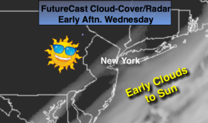
Wednesday:
Partly sunny, windy and brutally cold. Highs in the upper 20s. Wind chills 10º-15º.
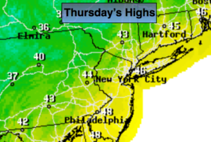
Thursday:
Partly sunny, breezy and cold. Highs around freezing.
Friday:
Mostly cloudy. Snow showers are possible. Highs in the mid 30s.
Keep it here for a no nonsense, no hype forecast.