Synopsis:
The remainder of the week looks pleasant under mostly sunny skies as high pressure takes control. Readings will start off below average for today ( the average high is 76º) then work to above average levels by Friday.
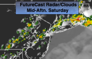
We may have to dodge some showers for this weekend. At this time it doesn’t look like a washout. The greatest threat of rain and thunderstorms is later Saturday and Saturday night. We may squeak out a dry Sunday if the front pushes far enough to the South.
Stay tuned.
Today:
Partly sunny. Highs around 70º. North to Southeast winds 5-10mph.
Tonight:
Mostly clear. Lows in the upper 50s in City, near 50º inland. Southeast winds at less than 5mph.
Thursday:
Mostly sunny. Highs in the lower to mid 70s.
Friday:
Mostly sunny, warmer. Highs in the lower 80s.
Saturday:
Partly sunny, warm and humid. Scattered afternoon thunderstorms. Highs around 80º.
Sunday:
Morning clouds will give way to partly sunny skies. It’ll be much less humid. Highs in the mid 70s.
Keep it here for a no nonsense, no hype forecast.