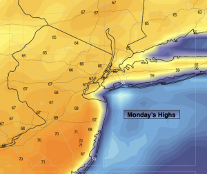
Synopsis:
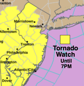
A Tornado Watch is in effect for much of NJ until 7pm. Scattered thunderstorms may turn severe with an isolated tornado possible. Keep an eye to the sky for threatening weather. This is all due to a cold front moving toward the region this evening. Some of the rainfall will be heavy. An inch of rain will be common. It’ll be windy. The timing for the potential severe storms looks to be between 5pm-11pm. The storms and showers will move off the coast toward midnight.
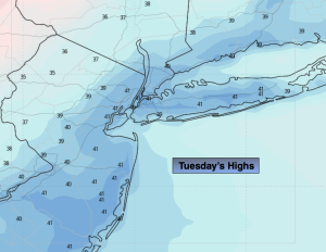
It’ll be cooler on Tuesday and Wednesday with abundant sunshine as high pressure moves from the Ohio Valley to off the East coast.
More seasonal temperatures are expected for Thursday, which is the last day of Winter!
Spring arrives Friday at 10:46am. Sun will give way to clouds. Temperatures will pop into the 50s!
A weak low will move through the region on Saturday with clouds. A few showers are possible. It doesn’t look like a washout.
Stay tuned.
Keep it here for a no nonsense, no hype forecast…
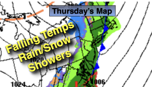
Tonight:
Showers and storms. Some of the storms maybe strong to severe (West). It all ends shortly after midnight. Windy. Lows in the 30s throughout. South to West winds at 15-25mph with gusts between 40-50mph.
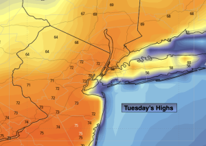
Tuesday:
Mostly sunny. Breezy and cooler. Highs in the lower 40s. West winds at 15-25mph with gusts to 30mph.
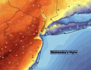
Wednesday:
Mostly sunny. Chilly. Highs around 40º.
Thursday:
Partly sunny. Seasonal. Highs in the mid to upper 40s.
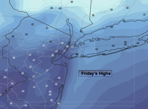
Friday:
Sun to clouds. Highs in the mid 50s.
Saturday:
Mostly cloudy. Few showers possible. Highs in the lower 50s.