Sun Returns for the New Year! Mild…


Synopsis

Happy New Year!

The sun will return for the start of the New Year. High pressure over the Southeast will strengthen and build along the Eastern seaboard through Monday. Today and tomorrow will be mainly sunny and mild.

Low pressure will move out of the Ohio Valley and toward the region Tuesday into Wednesday. Mainly cloudy skies are expected with the chance of showers just about anytime. It will not be a complete washout.

The jet stream through midweek will continue to be the atmospheric highway for a unseasonably mild time. Temperatures through this period will be ten to twenty degrees above the average high of around 40º. In fact, Wednesday most areas will experience readings in the 60s!

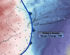
A cool front will move through on Thursday. We’ll cool off but still be a few degrees above average under a mix of clouds and sun.

Stay tuned.

Keep it here for a no hype, no nonsense forecast.

New Year’s Day:

Mostly sunny, breezy and mild. Highs in the mid 50s. Northwest winds at 10-20mph.

Tonight:

Mostly clear. Lows in the lower 40s along the urban corridor, the 30s inland. West Winds diminishing to 5mph.
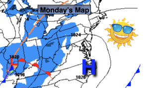
Monday:

Mostly sunny. Highs in the lower 50s.
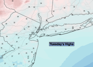
Tuesday:

Mostly cloudy. Scattered showers. Very mild. Highs in the mid to upper 50s.

Wednesday:

Mostly cloudy. Scattered showers. Balmy. Highs in  the lower 60s.
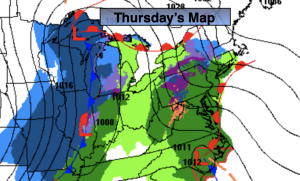
Thursday:

Sun and clouds. Cooler. Highs in  the mid 40s.

Sct’d Showers. More Widespread Toward Evening. Mild…


Synopsis

Scattered showers and mild temperatures will be the story for the last day of 2022. Areas of fog will add to the gloom, especially in the morning. Low pressure will move out of the Southern Appalachians. The showers will become more widespread toward evening. It’s a mild storm track. At the stroke of midnight there will be areas of rain and it’ll be very mild with readings around 50º!

The storm will move out of the region for New Year’s Day but the mild temperatures will stick around for the beginning of 2023 as all the cold air is locked up in Canada. It’ll be a mainly sunny for Monday, January 2nd.

Low pressure will move out of the Ohio Valley and toward the region later Tuesday and into Wednesday. Clouds and sun and a few showers later in the day are in the forecast for Tuesday. Periods of rain and balmy conditions are expected for Wednesday.

Temperatures through the the next five days will be ten to twenty degrees above the average high of around 40º.

Stay tuned.

Keep it here for a no hype, no nonsense forecast.

New Year’s Eve:

Cloudy with scattered showers and areas of morning fog. Mild. Highs in the mid 50s. East to Southeast winds at 5mph.

Tonight:

Areas of rain. Mild. Lows in the upper 40s along the urban corridor to the upper 30s and 40s inland. Winds becoming West at 5-10mph.

New Year’s Day:

Mostly sunny. Still mild. Highs in the mid 50s.

Monday:

Sunny. Highs around 50º.

Tuesday:

Clouds and sun. Chance of afternoon showers. Highs in the mid to upper 50s.

Wednesday:

Periods of rain. Balmy. Highs around 60º.

Late March Feel Friday. Abundant Sunshine…


Synopsis

High pressure off the Eastern seaboard will dominate our area today. A Southwest flow will result in a continued warming trend. Our trend of above average temperatures will continue (average temps are around 40º for highs) and readings will be at least ten degrees higher than normal for the rest of the five day period. Enjoy the break from the cold while it lasts!

The next chance of showers will come Saturday, New Year’s Eve. Low pressure will move out of the Southern Appalachians. Showers should develop by afternoon. It’s a mild storm track, equating to no snow. At the stroke of midnight rain is expected and it’ll be very mild with readings around 50º!

The storm will move out of the region for New Year’s Day but the mild temperatures will stick around for the beginning of 2023 as all the cold air is locked up in Canada. It’ll be a mainly sunny through the first few days in January. Not feeling like the season whatsoever.

Stay tuned.

Keep it here for a no hype, no nonsense forecast.

Friday:

Mostly sunny. Mild. Highs in the mid 50s. Southwest winds at 5-10mph.

Tonight:

Becoming mostly cloudy late. Milder than the average high for the date! Lows in the upper 40s along the urban corridor to the upper 30s and 40s inland. Light Southwest winds.

New Year’s Eve:

Mostly cloudy. Mild. Chance of afternoon rain. Highs in the mid 50s..

New Year’s Day:

Mostly sunny. Still mild. Highs in the lower to mid 50s.

Monday:

Sunny. Highs around 50º.

Tuesday:

Sunny. Highs in the mid 50s.

Bright & Mild Thursday…


Synopsis

High pressure will continue to build along the East coast through Friday. A Southwest flow will result in a continued warming trend. Our trend of above average temperatures will continue (average temps are around 40º for highs) and readings will be at least ten degrees higher than normal for the rest of the five day period. Enjoy the break from the cold while it lasts!

The next chance of showers will come Saturday, New Year’s Eve. Low pressure will move out of the Southern Appalachians. It’s a mild storm track, equating to no snow. At the stroke of midnight rain is expected and it’ll be very mild with readings around 50º!

The storm will move out of the region for New Year’s Day but the mild temperatures will stick around for the beginning of 2023. It’ll be a mainly sunny through January 2nd- Monday. Not feeling like January whatsoever.

Stay tuned.

Keep it here for a no hype, no nonsense forecast.

Thursday:

Sunny. Mild. Highs in the upper 40s to around 50º. Southwest winds at 5-10mph.

Tonight:

Mostly clear. Milder than the average high for the date! Lows in the mid 40s along the urban corridor to the upper 20s and 30s inland. Light Southwest winds.

Friday:

Mostly sunny. Mild. Highs in the mid 50s.

New Year’s Eve:

Mostly cloudy. Mild. Chance of afternoon rain. Highs in the lower 50s..

New Year’s Day:

Mostly sunny. Still mild. Highs in the mid 50s.

Monday:

Sunny. Highs around 50º.

Finally Above Average Temps. Bright Skies…


Synopsis

High pressure will continue to build along the East coast for the rest of the week. A developing Southwest flow will result in a warming trend. Temperatures will get above average today (average temps are around 40º for highs) and flirt with 50º for the rest of the five day period. Enjoy the break from the cold while it lasts!

The next chance of showers will come Saturday, New Year’s Eve. Low pressure will move out of the Southern Appalachians. It’s a mild storm track, equating to no snow. At the stroke of midnight rain is expected and it’ll be very mild with readings around 50º!

The storm will move out of the region for New Year’s Day but the mild temperatures will stick around for the beginning of 2023. It’ll be a mainly sunny January 1st.

Stay tuned.

Keep it here for a no hype, no nonsense forecast.

Wednesday:

Sunny. Milder. Highs in the mid 40s. Southwest winds at 5-10mph.

Tonight:

Mostly clear. Lows in the upper 30s along the urban corridor to the 20s inland. Light Southwest winds.

Thursday:

Sunny. Mild. Highs in the upper 40s to around 50º.

Friday:

Mostly sunny. Mild. Highs in the mid 50s.

New Year’s Eve:

Mostly cloudy. Mild. Chance of afternoon rain. Highs around 50º.

New Year’s Day:

Mostly sunny. Still mild. Highs in the mid 50s.

Out of the Freezer Today. Sun & Clouds…


Synopsis

We’ll finally come out of the ice box today. The frigid pool of air has lost its grip over the region. We have not been above freezing since last Friday afternoon. High pressure will continue to build along the East coast for the rest of the week. A developing Southwest flow will result in a warming trend. Temperatures will get above average by tomorrow (average temps are around 40º for highs) and flirt with 50º for the rest of the five day period. Enjoy the break from the cold while it lasts!

The next chance of showers will come Saturday, New Year’s Eve. Low pressure will move out of the Southern Appalachians. It’s a mild storm track, equating to no snow.

Stay tuned.

Keep it here for a no hype, no nonsense forecast.

Tuesday:

Mostly sunny. Highs in the mid 30s. West winds at 5-10mph.

Tonight:

Mostly clear. Lows around freezing along the urban corridor to the teens and 20s inland. West to Southwest winds at 5mph.

Wednesday:

Sunny. Milder. Highs in the mid 40s.

Thursday:

Sunny. Mild. Highs in the upper 40s to around 50º.

Friday:

Mostly sunny. Mild. Highs around 50º.

New Year’s Eve:

Mostly cloudy. Mild. Chance of late day showers. Highs around 50º.

Sun & Clouds. Not as Harsh…


Synopsis

A quiet last week of December is on the way. We’ll flirt with freezing today under a mix of sun and clouds. The frigid pool of air will finally move out of the region the next 24 hours and the winds will relax. A welcome change!

High pressure will build along the East coast the rest of the week. A developing Southwest flow will result in a warming trend. Temperatures will come out of the ice box and get to above average readings by midweek. Enjoy the break from the cold while it lasts!

Stay tuned.

Keep it here for a no hype, no nonsense forecast.

Monday:

Partly sunny. Not as harsh. Highs around freezing. West winds at 8-12mph.

Tonight:

Mostly cloudy. Lows in the mid 20s along the urban corridor to the teens and 20s inland. West winds at 5mph.

Tuesday:

Mostly sunny. Highs in the mid 30s.

Wednesday:

Sunny. Milder. Highs in the mid 40s.

Thursday:

Sunny. Mild. Highs in the upper 40s.

Friday:

Mostly sunny. Mild. Highs around 50º.

Arctic Blast for Christmas Eve…


Synopsis

Merry Christmas!

Christmas Eve will be be frigid especially compared to what we experienced 24 hours ago. Readings will only be in the mid to upper teens for highs and the wind will add a bite!  Wind chills will be within a few degrees of zero the majority of the day. Please dress in layers and avoid being outdoors for a long period of time. Skies will at least be bright.

Christmas Day will be frigid. Despite the sunshine readings will remain in the 20s. This will be one of the coldest Christmas’ in years!

We’ll flirt with freezing Monday under a bright sky and come out of the ice box on Tuesday as high pressure moves overhead. The mid to late week period looks quite mild and storm-free.

Stay tuned.

Keep it here for a no hype, no nonsense forecast.

Christmas Eve:

Sunny, windy and frigid. Highs only in the mid to upper teens. Wind chills near 0º the majority of the afternoon.  West winds at 15-30mph with higher gusts.

Tonight:

Clear, breezy and frigid. Lows in the mid teens along the urban corridor to the single digits to lower teens inland. Wind chills will be near below zero. West winds 15-325mph with higher gusts.

Christmas Day:

Sunny, breezy and very cold. Highs in the mid to upper 20s. Wind chills in the teens.

Monday:

Sunny. Cold. Highs around freezing.

Tuesday:

Sunny. Highs in the mid 30s.

Wednesday:

Sunny. Highs in the upper 30s.

Rain to Snow Showers Friday. Mild AM. Frigid PM. Windy…


Synopsis

It’ll be balmy this morning with most readings soaring into the 50s. Today will not be a washout. In fact only scattered showers are expected that will most likely change to snow showers as one of the sharpest Arctic front I’ve seen in years plows through. Winds will gust to 50mph before and after the front moves through. Temperatures will go from the 50s into the 20s within 4 hours. The sun will shine once the front moves through this afternoon.

Tonight will be bone-chilling cold as the Arctic blast grips the area. Lows will be in the single digits to lower teens. Winds will gust to 40mph making for windchills between -5º to -15º. Please dress in layers. This will be a major shock.

Saturday, Christmas Eve will be be frigid compared to what we experienced 24 prior. Readings will only be around 20º for highs and the wind will add a bite!  Wind chills will be in the single digits and teens. Get ready for a MAJOR shock. Skies will at least be bright.

Christmas Day will be frigid. Despite the sunshine readings will remain in the 20s. This will be one of the coldest Christmas’ in years!

We’ll flirt with freezing Monday under a bright sky and come out of the ice box on Tuesday as high pressure moves overhead.

Stay tuned.

Keep it here for a no hype, no nonsense forecast.

Tranquil conditions are expected through Wednesday as high pressure dominate.

Friday:

Early morning rain, otherwise mostly cloudy with any scattered showers changing to snow showers midday. Windy. Highs in the 50s to around 60º South. Winds gusting to 50mph. Tumbling temperatures during the afternoon into the 20s and teens by dark! Wind chills will be near 0º in many areas at this time.

Tonight:

Clear, windy and frigid. Lows in the lower teens along the urban corridor to the single digits inland. Wind chills will be well below zero. West winds 15-30mph with gusts to 45mph at the coast.

Christmas Eve:

Sunny, windy and frigid. Highs only around 20º Wind chills in the single digits and teens.

Christmas Day:

Sunny, breezy and very cold. Highs in the mid to upper 20s. Wind chills in the teens.

Monday:

Sunny. Cold. Highs around freezing.

Tuesday:

Sunny. Highs in the mid 30s.

Rain Develops Midday…


Synopsis:

Happy Hanukkah & Happy Winter!

A storm will begin to take shape over the Midwest today at the same time a second low will develop over North Carolina. This low will move North along with it a slug of rain. The rain will develop within a few hours of midday depending on location. Highs will be a few degrees above the average of 42º.

The storm over the Great Lakes will become very intense. Blizzard conditions and very strong winds are expected in this region. We are on the warm side of the storm. Rain may become heavy at times tonight into early Friday morning. One to two inches of rain is expected. Winds will increase and become quite strong.  It’ll be balmy Friday with most readings soaring into the 50s. Friday will not be a washout. In fact after the early morning rain ends only showers are expected that will most likely change to snow showers as one of the sharpest Arctic front I’ve seen in years plows through. Winds will gust to 50mph before and after the front moves through. Temperatures will go from the 50s into the 20s within 4 hours. The sun will shine once the front moves through Friday afternoon.

Saturday, Christmas Eve will be be frigid compared to what we experienced 24 prior. Readings will only be in the 20s for highs and the wind will add a bite!  Wind chills will be in the single digits and teens. Get ready for a MAJOR shock. Skies will at least be bright.

Christmas Day will be frigid. Despite the sunshine readings will remain in the 20s. This will be one of the coldest Christmas’ in years!

We’ll stay in the ice box Monday under a bright sky.

Stay tuned.

Keep it here for a no hype, no nonsense forecast.

Tranquil conditions are expected through Wednesday as high pressure dominate.

Thursday:

Rain developing from Southwest to Northeast during the midday hours. Becoming breezy late. Highs in the 30s well inland the 40s at the coast. East winds increasing later in the day to 10-20mph.

Tonight:

Rain, heavy at times. Windy. Mild with rising overnight temperatures. Readings will get into the 50s along the coast, the 40s inland. Southeast to East winds 15-30mph with gusts to 45mph at the coast.

Friday:

Early morning rain, otherwise mostly cloudy with any scattered showers changing to snow showers midday. Windy. Highs in the 50s to around 60º South. Winds gusting to 50mph. Tumbling temperatures during the afternoon into the 20s and teens by dark!

Christmas Eve:

Sunny and Frigid. Windy. Highs only in the 20s. Wind chills in the teens.

Christmas Day:

Sunny and Frigid. Breezy. Highs only in the 20s. Wind chills in the teens.

Monday:

Sunny. Cold. Highs around 30º.