Synopsis:
Clouds will give way to some sun today as the atmosphere dries out some. High pressure will park itself over the off the Eastern Seaboard this afternoon through Wednesday resulting in above average temperatures and dry conditions. Today and tomorrow will feel more like Summer and it will be humid.
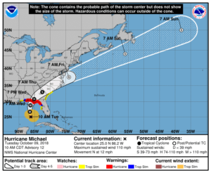
All eyes are on strengthening Hurricane Michael. The hurricane should become a powerful Category 3 storm with winds near 125mph and making landfall Wednesday somewhere along the panhandle or big bend area of Florida (map above). Damaging winds and flooding rains are likely.
By Thursday, a cold font will be approaching the region. Showers and thunderstorms are likely. Confidence continues to increase that Michael will stay just far enough South and East on Friday. The area should be spared of the storm’s affects. As always keep it here to JMW for the very latest on track of hurricane Michael.
You know where to find a no hype, no nonsense forecast.
Stay tuned.
Today:
AM Clouds to some sun. Warm & humid. Highs near 80º. South wind at 5-10mph.
Tonight:
Cloudy with areas of fog and patchy drizzle. Lows in the upper 60s in the City, the lower 60s inland. South to Southwest wind at 5mph.
Wednesday:
Clouds to some sun. Warm & humid. Highs near 80º.
Thursday:
Mostly cloudy with periods of rain and scattered storms. Humid. Highs in the mid 70s.
Friday:
Any clouds giving way to sun. Much cooler and less humid. Highs in the mid 60s.
Saturday:
Mostly sunny and very cool. Highs around 60º.
Keep it here for a no nonsense, no hype forecast.