Synopsis:
Scattered thunderstorms with torrential rain will occur over parts of the area this evening and into tonight as a weak disturbance interacts with the hot, humid airmass in place. Flash flooding may occur in the slower moving storms.
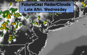
The heatwave will most likely break on Wednesday. The computer models have a flow coming off the colder Atlantic. This would result in readings in the 80s, but the high humidity will stick around. The combination of the very warm temperatures and high humidity will result in a heat index of 95º-100º. A heat advisory has been posted for July 4th for much of the area away from the coast. Mother Nature may provide her own fireworks on the 4th. Scattered showers and storms can occur just about anytime during the day and evening. Skies will be mostly cloudy. A washout is NOT expected.
Thursday will be back up near 90º as the wind will be more off the land.
A significant cool front will work into the region Friday afternoon and night with showers and thunderstorms. Relief will finally arrive by Saturday.
Stay tuned.
Tonight:
Scattered thunderstorms with torrential rain with the slow moving storms. Some areas will remain dry. Warm and muggy. Lows in the mid 70s in urban areas, near 70º elsewhere. Southeast winds under 5mph.
Wednesday:
Hazy, very warm and humid. Spotty storms are possible just about anytime. Highs in the mid to upper 80s. Heat index 95º.
Thursday:
Hazy, hot and humid. Highs in the upper 80s. Heat index 95º-100º.
Friday:
Hazy, very warm and humid. Showers and thunderstorms are likely. Highs in the mid 80s.
Saturday:
Mostly sunny, cooler and much less humid. Highs in the lower 80s.
Sunday:
Sunny with low humidity. Highs in the mid 80s.
Keep it here for a no nonsense, no hype forecast.