
Synopsis:
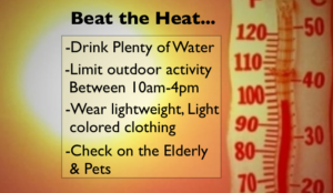
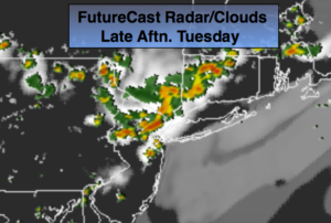
An area of high pressure will sit off the East coast through the week. This has and will continue to be responsible for the heatwave. Tuesday’s heat won’t nearly be as extreme as the last two days. The heatwave may break on Wednesday. The computer models have a flow coming off the colder Atlantic. This would result in readings in the 80s. A heatwave is defined as three consecutive days of 90º+. The combination of the high temperatures and high humidity will result in a dangerous heat index (how it actually feels) into Tuesday. A Heat Advisory is in effect for areas by the coast and the City. A heat index of 95-104º is expected. An Excessive Heat Warning is in effect for Tuesday for and many areas just inland from the coast. A Heat Index of around 105º is expected. Please take this situation seriously and listen to your body for signs of heat exhaustion. Drink plenty of fluids and try to limit your time outdoors between 10am-4pm. Spotty strong thunderstorms are possible later today with a disturbance moving through (FutureCast Radar above). Please keep an eye to the sky for threatening weather later this afternoon.
Mother Nature may provide her own fireworks on July 4th. Isolated storms are possible during the evening but a washout is NOT expected and most areas will remain storm-free.
Thursday will be back up near 90º as the wind will be more off the land.
A significant cool front will work into the region Friday afternoon and night with showers and thunderstorms. Relief will finally arrive by Saturday.
Stay tuned.
Today:
Hazy, hot and humid. Spotty PM storms are possible. Some of the storms maybe strong. Highs in the lower 90s. Much cooler by the ocean and over Eastern sections. Heat index 95º-105º.
Tonight:
An evening storm in spots, otherwise, partly cloudy, warm and muggy. Lows in the mid 70s in urban areas, near 70º elsewhere. Southeast winds under 5mph.
Wednesday:
Hazy, very warm and humid. An isolated PM Storm is possible. Highs in the upper 80s. Heat index 95º.
Thursday:
Hazy, hot and humid. Highs in the lower 90s. Heat index 95º-100º.
Friday:
Hazy, very warm and humid. Showers and thunderstorms are likely. Highs in the upper 80s. Heat index 95º.
Saturday:
Morning clouds will give way to a mostly sunny day. Cooler and much less humid. Highs in the lower 80s.
Keep it here for a no nonsense, no hype forecast.