Synopsis:
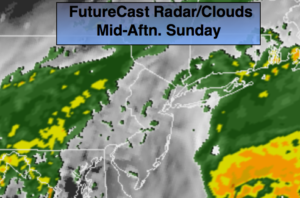
It’ll be a damp Sunday with on and off showers as a weak area of low pressure along a frontal boundary rides up the coast. It will not be a washout. In fact, there will be several hours of dry time (FutureCast above). It’ll be much cooler with readings several degrees below the average of 67º.
High pressure will work in for the beginning of the week. A couple of May gems are on the way. Tranquil weather looks to continue through the week as weather systems remain weak.
Stay tuned.
Today:
Cloudy with scattered showers. Highs in the lower 60s. Northeast winds at 5-10mph.
Tonight:
Cloudy with scattered showers. Lows in the lower to mid 50s in the City, the upper 40s inland. Northeast winds at 5-10mph.
Monday:
An early morning shower at the coast, otherwise, becoming partly sunny. Highs in the mid 60s.
Tuesday:
Sunny. Highs around 70º.
Wednesday:
Sunny. Highs in the lower 70s.
Thursday:
Sun to clouds. Highs in the lower 70s.
Keep it here for a no nonsense, no hype forecast.