Synopsis:
More comfortable temperatures will be with us for the weekend. A mix of clouds and sun is expected today. Readings will be much cooler than the last several days. A wave of low pressure along the dying cool front to the South will cause scattered showers to develop tonight. On and off showers are expected for Sunday. It will not be a washout. In fact, there will be several hours of dry time. It’ll be much cooler with readings several degrees below the average of 67º.
High pressure will work in for the beginning of the week. A couple of May gems are on the way.
Stay tuned.
Today:
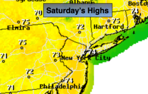
A mix of clouds and sun. Much more comfortable. Highs in the mid 70s. Northwest winds becoming Southwest at 5-10mph.
Tonight:
Cloudy with scattered showers after midnight. Lows in the 50s throughout. Southwest winds becoming Northeast less than 5mph.
Sunday:
Mostly cloudy with scattered showers. Highs in the lower 60s.
Monday:
Partly sunny. Highs in the mid 60s.
Tuesday:
Sunny. Highs around 70º.
Wednesday:
Sunny. Highs in the lower 70s.
Keep it here for a no nonsense, no hype forecast.