Synopsis:
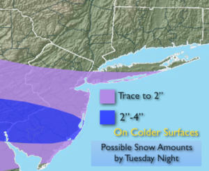
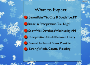
A developing storm will move out of the Tennessee Valley on tonight and Tuesday and move off the Virginia coast and to the East Northeast and out to sea. There remains a threat of a bit of snow or rain mainly to the South of the City on Tuesday. There will be a sharp cutoff to the precipitation on the Northern edge. Where this cutoff sets up is still in question. Will it clip the City and vicinity or will it remain South? An accumulating snow is possible if the heavier rates of snow occur, but it looks like this will be a minor event as the heaviest precipitation stays well South. Also, the sun angle will play into the equation of how much snow will stick during the daylight hours (it has to snow at a very good rate for snow to accumulate during the day). The possible amounts are above by Tuesday night. This is for storm #1 and think the lower end of the those numbers.
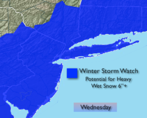
A second storm will develop with additional energy in the jet stream diving South into the Carolina’s. The storm will form East of the Outer Banks on Wednesday. The latest computer models are in unison. This storm will rapidly intensify and move to the Northeast just off the coast. The potential has increased for a Nor’easter on Wednesday if the latest track verifies. Wet snow and or rain which could be heavy at times by midday. A Winter Storm Watch has been posted for the entire area for the potential of 6″ or more of snow. Gusty winds and coastal flooding is possible if this storm comes close enough to the region on Wednesday and Wednesday night.
In summary, there will be two separate storms. One that may clip parts of the area (mainly South) on Tuesday the other that will have to be monitored closely for Wednesday and Wednesday night. Please check in frequently to this site. A high impact event could occur Wednesday. Please keep it here for a no hype, no nonsense forecast.
Stay tuned.
Tonight:
Mostly clear. Lows near 30º in the City, the teens & 20s inland. Northeast wind 5-10mph.
Tuesday:
Early sun possible otherwise thickening clouds. Chance of rain, wet snow & sleet South of the City. Highs in the upper 30s to lower 40s. Northeast 10-15mph.
Wednesday:
Wet snow, mix and rain changing to mainly wet snow and possibly becoming heavy at times. Windy conditions. Highs in the mid 30s.
Thursday:
Partly sunny and Windy. Highs in the lower 40s.
Friday:
Partly sunny, Breezy. Highs in the mid 40s.
Saturday:
Partly sunny. Highs in the mid 40s.
Keep it here for a no nonsense, no hype forecast.