Synopsis:
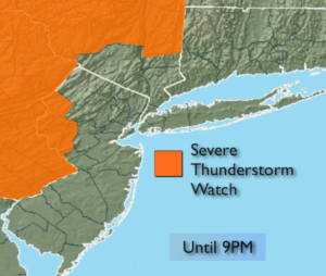
***Severe Thunderstorm Watch is in effect for Warren, Hunterdon, Dutchess, Ulster and Sullivan counties until 9PM*** A weak front will move into and through the region this evening and tonight. Showers and spotty thunderstorms are possible. A few storms over Northwestern areas may become strong to severe. The activity will taper off late tonight. Skies will be partly cloudy.
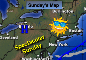
Sunday will be the better half of the weekend with abundant sunshine, warmer readings and much lower humidity as high pressure moves in.
The weather will cooperate for the beginning and middle portion of the week.
Stay Tuned.
Tonight:
An evening storm otherwise partly cloudy. Lows in the 60s throughout. Southwest to Northwest winds under 5mph.
Sunday:
Mostly sunny with lower humidity. Highs in the lower to mid 80s.
Monday:
Partly sunny. Highs in the lower 80s.
Tuesday:
Sun & clouds. Highs in the lower to mid 80s.
Wednesday:
Mostly sunny. Warm. Highs in the mid to upper 80s.
Thursday:
Hazy, warm and humid with spotty afternoon storms. Highs in the mid 80s.
Keep it here for a no nonsense, no hype forecast.