Synopsis:
High pressure will begin to move toward the region the next two days. This will result in mainly sunny skies today and Wednesday with seasonal temperatures and comfortable levels of humidity.
A moist Southwest flow will develop Thursday. The humidity will come up along with the chance of showers and storms during the afternoon.
The front will move off the coast on Friday with a few showers. The afternoon will feature more sun.
The last weekend of August looks spectacular with high pressure settling over the Northeast. Abundant sunshine and pleasant conditions are expected!
Stay tuned.
Keep it here for a no nonsense, no hype forecast….
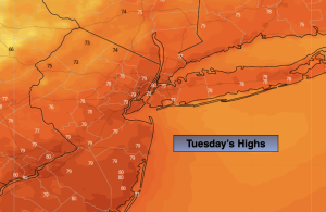
Tuesday:
Mostly sunny. Highs around 80º. Northwest at 8-12mph.
Tonight:
Mostly clear. Lows in the mid 60s in the City, the 50s elsewhere. Light West wind.
Wednesday:
Sunny. Highs around 80º.
Thursday:
Partly sunny. Afternoon showers and storms. More humid. Highs in the lower 80s.
Friday:
A few showers possible in the morning. A mix of sun and clouds during the afternoon. Highs in the lower 80s.
Saturday:
Sunny. Highs in the lower 80s.