Synopsis:
Today will be the better half of the weekend. Mostly sunny skies and pleasant temperatures are expected.
The week will start off bright and warm as high pressure moves overhead.
A warm front will move toward the area on Tuesday. A mix of sun and clouds is expected with the chance of afternoon storms.
Scattered showers are possible Wednesday as a cool front slows moves offshore.
Thursday will feature sunshine and comfortable temperatures as high pressure dominates the Northeast.
Stay tuned.
Keep it here for a no nonsense, no hype forecast….
Sunday:
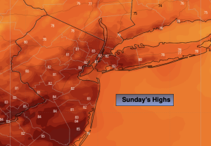
Mostly sunny. Highs in the lower to mid 80s. Northwest winds at 10-20mph.
Tonight:
Clear. Cooler than recent nights. Lows in the mid 60s in the City, the 50s & 60s inland. North wind at 5mph.
Monday:
Sunny. Highs in the lower 80s.
Tuesday:
Sun and clouds. Chance of afternoon storms. Highs in the lower 80s.
Wednesday:
Scattered showers. Highs in the lower 80s.
Thursday:
Sunny. Highs in the lower 80s.