Synopsis:
A cool front will be along the coast today. A period of light rain is likely for much of the area. The exception maybe regions to our North and West. It very well may remain dry here. Late day sun is possible as the impulse moves offshore. Readings will be well below the average highs of around 80º.
Wednesday and Thursday will be gems with weak high pressure in the vicinity. Abundant sunshine and warm temperatures are expected.
A front will approach the area Thursday night with scattered storms. Friday and Saturday will be mostly cloudy with scattered showers. It won’t be raining all the time. The unsettled conditions is a result of a front stalled just to our South.
The better half of the weekend will be Sunday. Sunny skies along with warm temperatures are anticipated.
Stay tuned.
Keep it here for a no nonsense, no hype forecast…
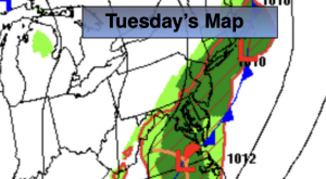
Tuesday:
A period of light rain for much of the region. Remaining dry North and West. Cooler. Highs 70º-75º. North wind at 5-10mph.
Tonight:
Becoming mostly clear. Comfortable. Lows in the lower 60s in the City, the 50s inland. Northwest winds at 5-10mph.
Wednesday:
Sunny. Warm. Highs in the lower to mid 80s.
Thursday:
Partly sunny. Highs in the lower 80s.
Friday:
Mostly cloudy. Scattered showers. Highs in the lower 80s.
Saturday:
Mostly cloudy. Scattered showers. Highs around 80º.