Synopsis:
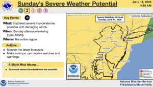
Heat and higher humidity will be with us today under a mix of sun and clouds. A cool front will approach this evening with scattered storms. Some of the storms maybe severe with damaging winds gusts. Keep an eye to the sky after 6pm tonight.
Monday through Wednesday will be more comfortable with lower temperatures and humidity. Skies will be partly sunny. Readings will be near the average highs of the upper 70s to around 80º.
Thursday will feature a warm push of air and higher humidity. Scattered late day storms are possible.
Stay tuned.
Keep it here for a no nonsense, no hype forecast…
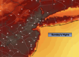
Sunday:
Partly sunny. Late day or evening storms possible. Highs around 90º. South to Southwest winds at 10-20mph.
Tonight:
Spotty evening storms, otherwise partly cloudy. Becoming less humid. Lows in the upper 60s in the City, the lower 60s inland. South to Northwest winds at 8-12mph.
Monday:
Mostly sunny. Cooler and less humid. Highs around 80º.
Tuesday:
Partly sunny. Highs in the mid to upper 70s.
Wednesday:
Partly sunny. Highs in the mid to upper 70s.
Thursday:
Partly sunny, warmer and more humid. Chance of late day storms. Highs in the upper 80s.