
Synopsis:
It’ll be a steamy Saturday as the hot Southwest flow continues around a Bermuda high. By this evening a cool front will approach. Spotty thunderstorms are likely. Some of the storms may reach severe limits (graphic above). Not everyone will get into the action. Eye to the sky for threatening weather after 5pm.
Sunday will feature relief behind the front. It now looks to be dry with a mix of sun and clouds.
Monday through Wednesday will feature abundant sunshine as high pressure moves from our area to off the Southeast coast. Temperatures will be above the average highs of the upper 70s by a few degrees on Monday and then become quite warm by midweek.
We desperately need some rain. Most areas are now in a moderate drought. Southern NJ is in a severe drought. The next five to ten days won’t offer any relief as weather patterns are not condusive for significant rainfall.
Stay tuned.
Keep it here for a no nonsense, no hype forecast…
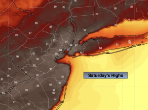
Saturday:
Mostly sunny. Hot. Spotty evening storm. Highs in the lower to mid 90s. Southwest winds at 10-20mph.
Tonight:
Spotty evening storm, otherwise, partly cloudy. Lows in the lower 70s in the City, the 60s inland. Light West wind.
Sunday:
Partly sunny. Highs in the mid 80s.
Monday:
Sunny. Highs around 80º.
Tuesday:
Sunny. Highs in the mid 80s.
Wednesday:
Mostly sunny. Highs in the upper 80s.