Synopsis:
High pressure over Southeast will move into the Western Atlantic through Saturday. This will result in bright skies and hot readings.
A spot thunderstorm is possible Saturday evening with the passage of a cool front. Most areas will remain storm-free.
Sunday will feature relief behind the front. It now looks to be dry with a mix of sun and clouds.
Monday and Tuesday will feature abundant sunshine as high pressure settles over the Northeast. Temperatures will be above the average highs of the upper 70s by a few degrees.
We desperately need some rain. Most areas are now in a moderate drought. Southern NJ is in a severe drought. The next five to ten days won’t offer any relief as weather patterns are not condusive for significant rainfall.
Stay tuned.
Keep it here for a no nonsense, no hype forecast…
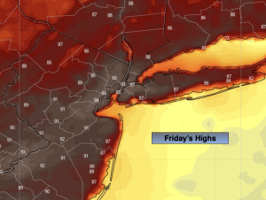
Friday:
Mostly sunny. Hot. Highs in the lower 90s. Southwest winds at 5-10mph.
Tonight:
Clear. Warm. Lows in the lower 70s in the City, the upper 50s and 60s inland. Light Southwest wind.
Saturday:
Mostly sunny. Hot. Spotty evening storm. Highs in the mid 90s.
Sunday:
Partly sunny. Highs in the mid 80s.
Monday:
Sunny. Highs around 80º.
Tuesday:
Sunny. Highs in the lower 80s.