Synopsis:
A weak front will move through today fairly uneventful. A mix of sun and clouds is expected. A spot shower can’t be ruled out. Readings will cool down but still be well above the average high of the lower 60s for this time of the year.
Saturday will feature a front just to our South. It’ll be partly sunny with readings a few degrees above average.
A cold front will finally move through the region on Sunday with showers and cooler temperatures.
A Canadian airmass will move in on Monday. It’ll be chilly with readings only in the lower 50s!
Tuesday will be bright and cool as high pressure moves overhead.
Our dry streak continues. Please use caution with flammables outdoors as the spread for wild fires is a concern.
Stay tuned.
Keep it here for a no nonsense, no hype forecast…
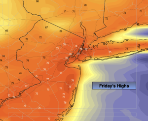
Friday:
Partly sunny. Spot shower. Still mild. Highs in the upper 70s. North wind at 8-12mph.
Tonight:
Partly cloudy. Lows in the 50s throughout. Northeast winds at 5 mph.
Saturday:
Partly sunny. Cooler. Highs in the mid 60s.
Sunday:
Mostly cloudy with showers. Highs around 60º.
Monday:
Mostly sunny. Chilly. Highs only around 50º.
Tuesday:
Mostly sunny. Cool. Highs in the mid 50s.