Synopsis:
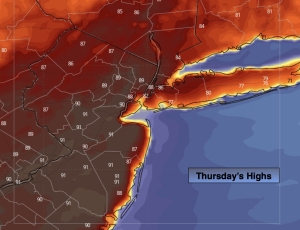
Our Summer preview will continue through today with highs reaching well into the 80s to around 90º. Temperatures will be cooler at the coast and over Long Island with an Atlantic influence. Record highs for Thursday looked to be just missed. The record for Central Park for Thursday is 92 set in 2002. The weather pattern will be more reminiscent of July than April as a Bermuda high dominates. A mix of sun and clouds is expected.
A weak front will move through Friday uneventful. Readings will cool down but still be well above the average high of the lower 60s for this time of the year.
Saturday will feature a front just to our South. It’ll be partly sunny and still mild for this time of the year.
A cold front will finally move through the region on Sunday with showers and cooler temperatures.
A Canadian airmass will move in on Monday. It’ll be chilly with readings only in the lower 50s!
Our dry streak continues. Please use caution with flammables outdoors as the spread for wild fires is a concern.
Stay tuned.
Keep it here for a no nonsense, no hype forecast…
Thursday:
Partly sunny. Very warm. Highs in the upper 80s. Cooler at the coast. Southwest winds at 10-20mph.
Tonight:
Partly cloudy. Spotty showers or thunderstorm possible. Lows in the 60s throughout. Southwest to West winds at 5mph.
Friday:
Partly sunny. Still warm. Highs around 80º.
Saturday:
Partly sunny. Cooler. Highs in the upper 60s.
Sunday:
Mostly cloudy with showers. Highs in the lower to mid 60s.
Monday:
Mostly sunny. Chilly. Highs only in the lower 50s.