Synopsis:
After nine consecutive days with temperatures below freezing we finally got above the 32º mark on Monday. We’ll do it all over again today under a mix of sun and clouds. It’s a heatwave!
Wednesday and Thursday will feature readings within a few degrees of freezing along with mostly sunny skies as high pressure dominates.
On Friday, a cold front will be approaching. Scattered snow showers are possible later in the afternoon or evening. It doesn’t look to be a big deal. The big deal will be the Arctic blast that will arrive this upcoming weekend. Temperatures will only be in the teens with a biting wind and dangerous wind chill. Sigh…
Stay tuned.
Keep it here for a no nonsense, no hype forecast…..
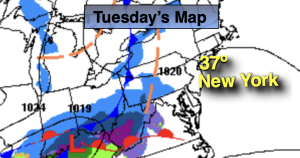
Tuesday:
Partly sunny. Highs in the mid 30s. West winds at 8-12mph.
Tonight:
Partly cloudy. Lows in the mid 20s along the coast, the single digits and teens inland. Northwest wind to 5-10mph
Wednesday:
Partly sunny. Highs around freezing.
Thursday:
Mostly sunny. Highs around 30º.
Friday:
Sun to clouds. Scattered snow showers possible during the late afternoon or evening. Highs around 30º.
Saturday:
Mostly sunny, windy and bitterly cold. Highs in the mid to upper teens. Wind chills near 0º.