Synopsis:
We have had nine consecutive days with temperatures below 32º. We’ll finally get some relief from the bitter cold this week. The core of the Arctic dome will move East allowing temperatures to rise to near freezing the next few days. A mix of sun and clouds is expected as a ridge of high pressure dominates. A few flurries or snow showers are possible Tuesday night into early Wednesday morning. This will not be a big deal.
By Friday, a cold front will be approaching. Scattered snow showers are possible, again not looking like a big deal.
Stay tuned.
Keep it here for a no nonsense, no hype forecast….
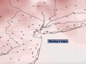
Monday:
Mostly sunny. Highs in the lower 30s. Northwest winds at 10-20mph.
Tonight:
Mostly clear. Lows in the lower 20s along the coast, the single digits and teens inland. Decreasing Northwest wind to 5-10mph.
Tuesday:
Partly sunny. Highs around freezing.
Wednesday:
Early AM flurry, otherwise, partly sunny. Highs around freezing.
Thursday:
Mostly sunny. Highs in the upper 20s.
Friday:
Scattered snow showers possible. Highs around 30º.