Synopsis:.
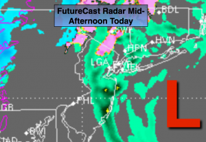
The Nor’easter will continue to move up and just off the coast today. The good news is that the heaviest precipitation and highest wind field has moved into New England. On and off Light rain is expected with areas of drizzle. North and West on and off wet snow or sleet is possible, especially at the higher elevations. There will be dry times. The thinking is as the storm continues to meander offshore a more organized area of precipitation will swing back to the the West from the ocean this afternoon. The FutureCast radar above shows this. At this time the atmosphere maybe cold enough for wet snow or sleet to be mixed in closer to the coast. Don’t be surprised if a burst of wet snow or sleet occurs at or near the coast. Any area has the possibility of picking up a slushy coating of sleet or wet snow later today.
As the storm pulls away Wednesday we’ll finally get to see the sun! There is no cold air behind the Nor’easter so Spring-like readings are expected.
A cold front will swing through Thursday. The mercury will come down is steps as we head into the weekend.
A more Winter-like pattern looks to be in the cards as February nears. Will the storm track be favorable for snow? Stay tuned.
Today:
Scattered areas of rain and drizzle. Wet snow and sleet at times inland. A period of steady and heavier precipitation is expected for most later this afternoon. Highs around 40º in the City, 30s inland. Northeast to Northwest wind at 15-25mph with gusts to 30mph.
Tonight:
Scattered areas of rain, wet snow or sleet will come to an end otherwise, mostly cloudy. Lows in the mid 30s in the City, upper 20s inland. Northwest wind at 15-25mph.
Wednesday:
Partly sunny and mild. Highs around 50º.
Thursday:
Partly sunny and mild. Highs in the upper 40s.
Friday:
Partly sunny, windy and cooler. Highs in the around 40º.
Saturday:
Partly sunny, more seasonal. Highs in the upper 30s.
Stay Tuned.
Keep it here for a no nonsense, no hype forecast.