Synopsis:.
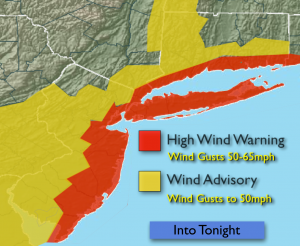
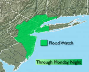
The Nor’easter will make its presence known tonight. Periods of heavy rain is expected. One to three inches of rain is possible. A Flash Flood Watch is up for most of the tri-state area. Wind gusts up of 40-65mph are possible along the coast. A High Wind Warning is in effect for the entire coast and all of New York City for Monday. Coastal flooding is possible at the times of high tide. Tides may reach 2 1/2 feet to 4 feet above normal at times of high this evening and tomorrow morning.
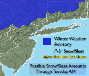
Wet snow or sleet will occur inland over the higher elevations of Sussex county NJ, the Poconos and Catskills Monday tonight into Tuesday. An accumulation of snow and sleet is possible. Winter Weather Advisories have been posted (map above for possible snow amounts). Snow and sleet may mix in for a time farther to the South and East of the Advisories. Don’t be surprised in areas of interior Northern and Central NJ and lower NY State if frozen precipitation falls. The storm will pull away slowly Tuesday with on and off rain expected. Mixed precipitation inland. Winds will diminish.
A more Winter-like pattern looks to be in the cards for the end of January and into February. Stay Tuned.
Tonight:
Periods of rain, heavy at times. Chance of wet snow/sleet inland at times, especially over the higher elevations. An accumulation is possible in the advisory area. Lows around 40º in the City, the 30s inland. Northeast winds 15-30mph with gusts to 60 along the coast.
Tuesday:
Scattered areas of rain. Wet snow and sleet at times inland. Highs in the lower 40s in the City, 30s inland. Northeast to Northwest wind at 15-25mph with gusts to 30mph.
Wednesday:
Partly sunny and mild. Highs around 50º.
Thursday:
Partly sunny and mild. Highs in the upper 40s.
Friday:
Partly sunny, windy and cooler. Highs in the around 40º.
Saturday:
Partly sunny, more seasonal. Highs in the upper 30s.
Stay Tuned.
Keep it here for a no nonsense, no hype forecast.