Synopsis:
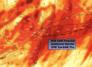
Low pressure will move along the NJ coast to Eastern Long Island tonight. Areas of heavy rain, high winds coastal flooding and fresh water flooding can be expected. The rain and wind will taper off from South to North late tonight.
Flood Watches have been posted for potential flooding of streams, rivers and highways. Additional heavy rainfall is expected through tonight. High Wind Warnings and Advisories are up for the region. Winds along the coast may gust between 50-60mph. 40-50mph gusts are possible elsewhere. Coastal flooding Watches and Warnings have been issued. Tidal flooding is likely especially at times of high tide.
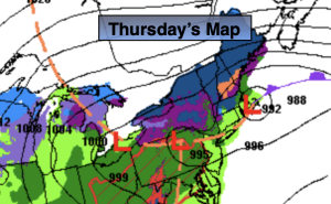
Thursday morning should be mainly dry. The backside of the storm will draw colder air into the atmosphere so any rain showers have the possibility of going over to snow showers inland. If we’re lucky we’ll get to see a peek of sun.
Friday and Saturday the storm will be East of New England and weakening. We’ll be left with upper low pressure swinging through the region. This will cause the atmosphere to be unstable. A spotty shower is possible Friday afternoon under a mix of sun and clouds. A gusty Northwest breeze will create a nip in the air. We’ll definitely be experiencing Spring’s chilly side through the period.
Sunday will be the better half of the weekend with high pressure moving in. Readings will be more seasonable in the mid to upper 50s under abundant sunshine.
High pressure will dominate on Monday. This should provide decent viewing conditions for the solar eclipse. Mostly sunny skies are forecast with mild readings.
Stay tuned.
Keep it here for a no nonsense, no hype forecast.
Tonight:
Heavy rain. Tapering off late. Lows around 40º in the City, the 30s inland. Northeast to Northwest winds at 15-30mph with gusts to 50-60mph at the coast, diminishing late.
Thursday:
Mostly cloudy. Scattered rain and snow showers (inland). Highs in the mid to upper 40s. Northwest winds at 8-15mph.
Friday:
Clouds and sun. Breezy. Spotty afternoon shower. Highs around 50º.
Saturday:
Clouds and sun. Breezy. Highs in the lower 50s.
Sunday:
Mostly sunny. Milder. Highs in the mid to upper 50s.
Monday:
Mostly sunny. Highs in the lower 60s.