Synopsis:
On Presidents’ Day, a mild push will arrive as winds turn to the Southwest around departing high pressure offshore. Highs will be ten degrees above average under abundant sunshine.
For once in a longtime most areas temperatures will be above freezing tonight.
Low pressure will head toward the region Tuesday. Thickening clouds and showers are expected by afternoon. It’ll will be mild.
Wednesday will greet us with another Spring preview as we’ll be in between systems. Cold air will remain well to the North.
Thursday should be dry but the next in a series of low pressure systems will throw clouds our way. It’ll be much cooler as the flow will turn out of Canada.
On Friday, low pressure will move up the spine of the Appalachians. It should be cold enough for mixed precipitation during the morning. Enough warm air should work into the system for mainly rain for a majority of the day.
Stay tuned.
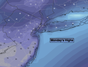
Monday:
Mostly sunny. Milder. High in the lower to mid 50s. Southwest to South winds at 5mph.
Tonight:
Clear to partly cloudy. Much milder than recents nights. Lows in the mid and upper 40s in the City, the 30s inland. South to East winds less than 5mph.
Tuesday:
Thickening clouds. Showers likely by midday. Mild. High in the mid 50s.
Wednesday:
Sun and clouds. Warm. High in the lower to mid 60s.
Thursday:
Clouds and sun. Much cooler. High around 40º.
Friday:
Mixed precipitation to mainly rain. High around 40º.