Synopsis:
Low pressure will head toward the area today. Clouds will thicken and showers are expected by afternoon. It’ll be mild.
A period of rain and wind is likely tonight as the low and front move through. Readings will be very mild.
Wednesday will greet us with another Spring preview as we’ll be in between systems. Cold air will remain well to the North. Highs will approach records in some regions.
Thursday should be dry but the next in a series of low pressure systems will throw clouds our way. It’ll be much cooler as the flow will turn out of Canada.
On Friday, low pressure will move up the spine of the Appalachians and then off the coast just to our South. It should be cold enough for mixed precipitation during the morning. Enough warm air should work into the system for mainly rain for a majority of the day. Ice may continue well inland.
Cold high pressure will work into the region on Saturday. At least the sun will shine.
Stay tuned.
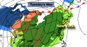
Tuesday:
Thickening clouds. Showers likely during the afternoon. Mild. High in the mid 50s. East to South winds at 8-15mph.
Tonight:
Rain with gusty winds. Very mild. Lows mainly in the 50s throughout. South to Southwest winds at 15-25mph with gusts to 35mph. Winds will diminish late.
Wednesday:
Sun and clouds. Warm. High in the lower to mid 60s.
Thursday:
Clouds and sun. Much cooler. High in the upper 30s.
Friday:
Mixed precipitation to mainly rain. High around 40º.
Saturday:
Sunny. Cold. High in the mid 30s.