Synopsis:
Today is the last day of Summer (that was hard to write!). Partly sunny skies and comfortable temperatures are in the forecast.
As we turn the page to Autumn on Wednesday (the Equinox occurs at 3:21PM) a cool front will be approaching. More clouds than sun is expected. It will be humid with a Southerly wind. Spotty showers can’t be ruled out.
The front will be a slow mover. Showers are likely on Thursday. How fast the front moves offshore will determine if Friday will be dry or showery. Right now, I’m keeping the threat of showers in the forecast for Friday morning.
The weekend should start off bright and comfortable.
Stay tuned.
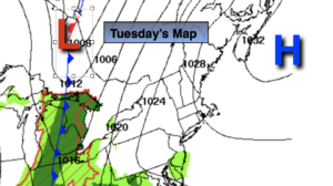
Tuesday:
Partly sunny. Highs in the mid 70s. East to Southeast winds at 8-12mph.
Tonight:
Mostly cloudy. Lows in the mid to upper 60s in the City, around 60º inland. East to Southeast winds at 5-10mph.
Wednesday:
Clouds with peeks of sun. Spotty showers possible. Humid. Highs in the mid to upper 70s.
Thursday:
Mostly cloudy with scattered showers. Highs in the mid 70s.
Friday:
Mostly cloudy with scattered showers possible in the morning. Highs in the mid 70s.
Saturday:
Partly sunny. Highs in the mid 70s.