Synopsis:
Once again like yesterday, it will be all about location today. A weak stubborn low off the NJ coast will bring a more pessimistic forecast to coastal areas. This system continues to crawl to the North and East and will be over Long Island during the day. Spotty showers are possible just about anytime for coastal regions and the immediate NYC vicinity. Just to the West it will be drier with more sunshine and much warmer readings. In areas where clouds hang tough and showers fall temperatures will be below the average high of the mid 80s.
This upcoming week will be more August like as high pressure builds over the Western Atlantic- a Bermuda high. This is very typical for this time of the year. The dog days of August will be upon us. Hazy, increasingly hot and humid conditions can be expected. A late day scattered storm is possible each and every day.
Keep it here for a no nonsense, no hype forecast.
Stay tuned.
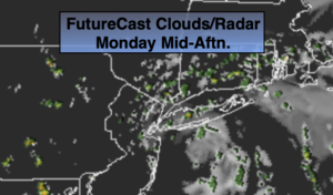
Today:
Clouds dominate by the coast where scattered showers are possible. Inland, the sun will rule. Highs around 80º at the coast. The mid to upper 80s inland. Northeast winds at 5-10mph.
Tonight:
Mostly cloudy. Spotty drizzle possible. Lows in the lower 70s in urban areas, the 60s inland. North to East winds at 5mph.
Tuesday:
Hazy. Very warm and humid. Scattered PM Storm. Highs in the upper 80s.
Wednesday:
Hazy, hot and humid. Scattered PM Storm. Highs in the lower 90s. Heat index near 100º.
Thursday:
Hazy, hot and humid. Isolated PM storm. Highs in the lower to mid 90s. Heat index near 100º.
Friday:
Hazy, hot and humid. Scattered PM storm. Highs in the lower to mid 90s. Heat index near 100º.