Synopsis:
Fantastic early Spring weather will continue through the week as high pressure remains in control. The only minor hiccup will be a spotty shower chance West of the City this morning as a weak upper level disturbance rapidly moves through, otherwise skies will be mostly sunny. It will be warm today.
Readings Thursday and Friday will still be above average by a few degrees as the wind turns to an onshore flow.
The weekend will be a 50/50 split. Saturday will be the better half. It will be partly sunny with just the chance of a shower in the morning. On Sunday, low pressure will work up from the South. Rain is likely for a part of the day.
Keep it here for a no nonsense, no hype forecast.
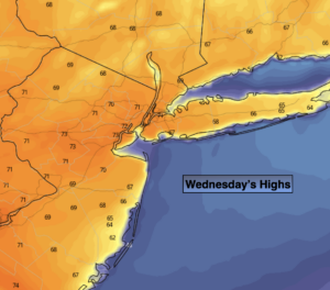
Today:
Early clouds and a spot shower chance West, otherwise sunny and warm. Highs around 70º. Cooler at the coast. North to Northeast winds at 5-10mph.
Tonight:
Clear and mild. Lows in the lower 50s in the City, the 40s inland. Southeast wind at 5mph.
Thursday:
Sunny. Highs in the mid 60s.
Friday:
Sun and clouds. Highs in the lower 60s.
Saturday:
Clouds, some sun. A spot shower is possible in the morning. Highs around 60º.
Sunday:
Periods of rain. Highs around 60º.