Synopsis:
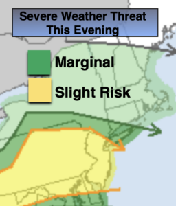
Hazy sun into this evening. This will destabilize the atmosphere. Round 2 of scattered showers and storms will develop through the evening. Some of the storms may reach severe limits, especially over Southern areas where a Severe Thunderstorm Watch is in effect until 10PM for Ocean County. Not everyone will get in on the action.
Skies will become partly cloudy overnight. It will be mild.
Thursday will be warm under a mix of sun and clouds. The humidity will be a tad lower. A weak stationary front will be draped over the area. Another disturbance will work in Thursday night with scattered showers and storms.
Friday will be partly sunny, not was warm, but more humid.
A cool front will approach Saturday it will be warm ahead of the front. Scattered showers are possible under a partly cloudy sky but most of the day will be dry.
Sunday will be more comfortable with plenty of sunshine as high pressure influences our area from the Northwest.
Stay Tuned.
Keep it here for a no nonsense, no hype forecast.
Rest of Today:
Clouds and hazy sun. Warm and humid. Scattered storms redeveloping this evening. Many areas will be storm-free.Temperatures will be in the 70s and 80s.
Tonight:
Mostly cloudy with scattered showers and thunderstorms during the evening, otherwise becoming partly cloudy. Lows 60º-65º throughout. West winds at 5mph.
Thursday:
Partly sunny, warm and less humid. Highs in the mid 80s.
Friday:
Partly sunny. Highs in the lower 80s.
Saturday:
Partly sunny. Scattered showers. Highs in the mid 80s.
Sunday:
Mostly sunny. Much lower humidity. Highs in the upper 70s.
Monday:
Sunny. Comfortable. Highs in the upper 70s.