Synopsis:
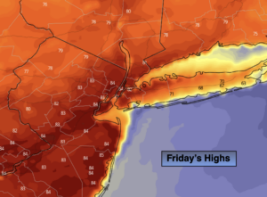
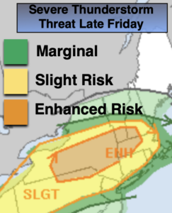
If you have been waiting for some warm weather, your wish will be granted today. Temperatures sky rocket into the 80s as a strong Southwesterly flow takes shape-a late June feel for sure. Morning clouds and isolated showers will give way to partly sunny skies. A few late day showers or thunderstorms are possible as a front approaches (most areas will be storm-free). Some of the isolated storms in the late afternoon have a chance of becoming severe especially North and West of the City. Severe thunderstorms have winds in excess of 58mph and or 3/4″ hail.
Scattered showers and storms are possible tonight when the front pushes through the area. It’ll be quite warm.
The weekend looks decent. On Saturday, morning clouds and isolated early morning showers will give way to mostly sunny skies. It’ll be warm with readings several degrees above the average high of 70º. Sunday will be cooler as high pressure over the Northeast moves offshore and a wind off the cooler Atlantic takes hold. Skies will start off sunny but clouds will increase during the day.
The beginning of the week will be unsettled with low pressure to the South moving at a snails pace. Scattered showers are possible Monday and Tuesday.
Stay Tuned.
Keep it here for a no nonsense, no hype forecast.
Today:
Morning clouds and isolated showers with give way to partly sunny skies. It will be much warmer. Chance of isolated late day showers or storms. Highs 80º-85º. Southwest winds at 10-20mph.
Tonight:
Scattered showers and storms. Very warm. Lows in the lower to mid 60s in the City, the 50s inland. Southwest to Northwest winds at 5-10mph.
Saturday:
Early morning clouds and isolated showers, otherwise mostly sunny. Warm. Highs in the mid to upper 70s.
Sunday:
Partly sunny. Cooler. Highs in the mid 60s.
Monday:
Mostly cloudy with a chance of showers. Highs in the mid 60s.
Tuesday:
Mostly cloudy with a chance of showers. Highs in the lower 60s.