Synopsis:
An Intense storm over Eastern New England will continue to pull away from the coast tonight. The high winds and rounds of rain and snow showers will diminish this evening. It will be much colder than it’s been with cold air funneling in from Canada. All areas will be below freezing.
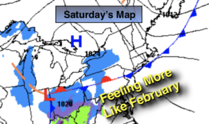
The weekend looks decent for February standards as high pressure moves in from the West. Saturday will be tranquil and cold under a mix of sun and clouds with readings near the seasonal average of 40º. Sunday will be a tad milder under partly sunny skies.
A weak system will move in from the West on Monday. Showers are possible.
Tuesday clouds will dominate. Showers are possible over Southern sections as moisture rides along a front just to the South.
There still is no significant snow in the foreseeable future.
Stay Tuned.
Keep it here for a no nonsense, no hype forecast.
Tonight:
Early evening rain and snow showers, otherwise becoming mostly clear and much colder. Winds will begin to diminish. Lows in the upper 20s in the City, near 20º inland. West winds at 15-30mph and diminishing.
Saturday:
Partly sunny. Highs around in the 30s to around 40º. West winds at 8-12mph.
Sunday:
Sun and clouds. Highs in the lower to mid 40s.
Monday:
Mostly cloudy with scattered showers. Highs in the upper 40s.
Tuesday:
Mostly cloudy. Showers are possible to the South. Highs in the mid 40s.
Wednesday:
Partly sunny. Highs in the mid 40s.