Synopsis:.
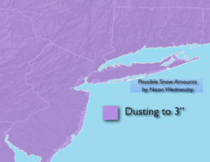
Snow will end from West to East during the morning. A dusting to 3″ of snowfall is expected. The highest amounts look to fall closer to the coast and over parts of Long Island. The sun will return along with much colder readings during the afternoon.
Tonight will be clear and cold. All readings will be well below freezing.
Cold high pressure will work over the region on Thursday. Despite the abundant sunshine readings will only be near freezing.
It won’t be as harsh on Friday under a mix of sun and clouds.
A storm will ride up the coast Friday night and Saturday morning. Another round of rain is expected. There is no cold air available for this to be snow.
It looks to remain active heading into next week.
Stay Tuned.
Keep it here for a no hype, no nonsense forecast.
Wednesday:
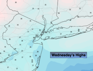
Morning snow ending from West to East, otherwise becoming mostly sunny and colder. Highs only in the mid to upper 30s. Northwest winds at 8-12mph.
Tonight:
Clear. Much colder. Lows in the mid 20s in the City, the teens to lower 20s inland. Northwest winds at 10-15mph with higher gusts.
Thursday:
Sunny and cold. Highs 30º-35º.
Friday:
Sun to afternoon clouds. Highs in the mid 40s.
Saturday:
Morning rain. Afternoon sun. Mild. Highs in the mid 50s.
Sunday:
Partly sunny. Highs in the mid 40s.