Synopsis:.
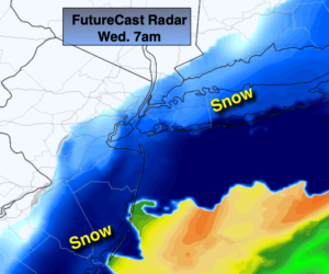
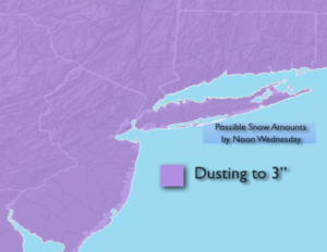
Tonight a potent cold front will swing through. Rain will turn to a period of snow overnight into Wednesday morning. If the leftover precipitation is heavy enough there could be some accumulation. At this time there is the potential for a dusting to 3″ of snowfall. The highest amounts look to fall closer to the coast. The sun will return along with much colder readings during the afternoon.
Cold high pressure will work over the region on Thursday. Despite the abundant sunshine readings will only be near freezing.
It won’t be as harsh on Friday under a mix of sun and clouds.
A storm will ride up the coast Friday night and Saturday morning. Another round of rain is expected. There is no cold air available for this to be snow.
It looks to remain active heading into next week.
Stay Tuned.
Keep it here for a no hype, no nonsense forecast.
Tonight:
Periods of rain will change to periods of snow from Northwest to Southeast. Colder. Lows in the lower to mid 30s in the City, the upper 20s inland. North to Northwest winds at 8-12mph.
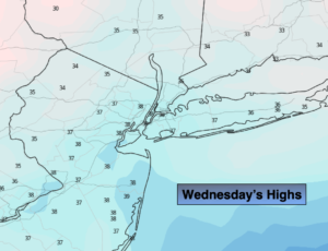
Wednesday:
The potential for a period of morning snow, otherwise becoming mostly sunny and colder. Highs only in the mid to upper 30s. Northwest winds at 8-12mph.
Thursday:
Sunny and cold. Highs 30º-35º.
Friday:
Sun to afternoon clouds. Highs in the mid 40s.
Saturday:
Morning rain. Afternoon sun. Mild. Highs in the mid 50s.
Sunday:
Partly sunny. Highs in the mid 40s.