Synopsis:
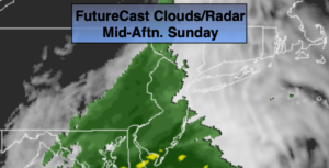
The remnants of Tropical Storm Nestor will ride up the coast. The storm should move off the North Carolina coast and brush our area with clouds. There will be a few hours of sun this morning, especially over Eastern sections. Most areas will get into the rain shield from the dying storm by afternoon. Well to the North and West it may remain dry, the steadiest rain will be along the coast. It will be raw with readings only in the mid to upper 50s.
Any light rain or showers will end this evening. Skies will become partly cloudy.
Monday looks bright with high pressure moving in.
The next chance of showers will be later Tuesday afternoon with a cool front.
Wednesday and Thursday will be tranquil with plenty of sun as another high dominates.
Stay Tuned.
Keep it here for a no nonsense, no hype forecast.
Today:
Early sun (mainly East) otherwise, mostly cloudy. A chance of showers or a period of rain for most of the area this afternoon, excluding regions well North and West. Cool. Highs in the upper 50s. East to Northeast winds 8-12mph.
Tonight:
Spotty rain this evening, otherwise becoming partly cloudy. Lows around 50º in the City, the 30s & 40s North and West. Northeast to North winds at 10-15mph.
Monday:
Sunny. Highs in the mid 60s.
Tuesday:
More clouds than sun. Chance of afternoon showers. Highs in the mid 60s.
Wednesday:
Partly sunny. Highs in the lower to mid 60s.
Thursday:
Sunny. Highs in the mid 60s.