Synopsis:
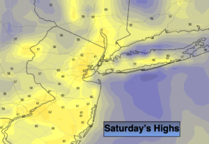
After a cold and frosty morning in many locations it’ll become a fall classic today with abundant sunshine and readings just below the average high of 64º as high pressure slips off the Eastern seaboard.
Skies will become partly cloudy tonight and it won’t be as cold as last night.
On Sunday Tropical Storm Nestor (or the remnants of) will ride up the coast. The storm should move off the North Carolina coast and brush our area with clouds on Sunday. It now looks like at least the I-95 corridor will get into the rain shield. Well to the North and West it should remain dry, but many areas will be damp on Sunday. JMW will continue to monitor the latest guidance on the track of this potential system.
Monday looks bright with high pressure moving in.
The next chance of showers will be later Tuesday afternoon.
Stay Tuned.
Keep it here for a no nonsense, no hype forecast.
Today:
Sunny and cool. Highs around 60º. Northwest to South winds at 5mph.
Tonight:
Partly cloudy. Lows around 50º in the City, the 30s & 40s North and West. Southwest to East winds less than 5mph.
Sunday:
Mostly cloudy. A chance of showers or a period of rain for most of the area, excluding regions well North and West. Cool. Highs in the upper 50s.
Monday:
Sunny. Highs in the mid 60s.
Tuesday:
Sun to clouds. Chance of afternoon showers. Highs in the mid 60s.
Wednesday:
Partly sunny. Highs in the lower to mid 60s.