Synopsis:
Two systems will influence our weather through tomorrow. A low in the Western Atlantic and high pressure over Southeastern Canada.
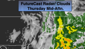
It looks like enough dry area will work in from the North from the Canadian high to keep much of the day dry today, especially from the NYC vicinity and to the West. In fact, the sun may shine from time to time. Eastern sections will be in and out of the rain. This rain shield will creep back towards the City later in the day.
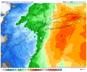
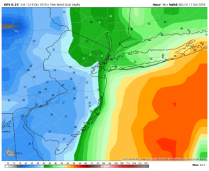
The ocean storm will be at it’s closest proximity to our area (about 150 Southeast of Eastern Long Island) late this afternoon. There will be a strong pressure gradient between the high and the low. This will result in windy conditions both Thursday and Friday. The steadiest rain and highest winds look to be over Eastern Long Island and Eastern Connecticut. Peak winds will occur later this afternoon. Gusts around 55mph are possible over Eastern Long Island. Winds will gust between 30-45mph over the rest of the tri-state coastal area. The second map above is the 3KM NAM model for winds late day Thursday. This is the most robust model with wind. The third map is the GFS model which isn’t quite as strong with the gusts.
Coastal flooding is a concern today and Friday. Those areas that are most vulnerable to tidal flooding should be on alert. Tides may run up to 3′ above normal.
The storm will slowly drift to the South and then out to sea later Friday. Spot showers are possible. The sun may try to shine from time to time.
The weekend looks decent with a mix of sun and clouds and near seasonal readings, which is in the mid 60s. Sunday is the pick day.
Stay Tuned.
Keep it here for a no nonsense, no hype forecast.
Today:
Mostly cloudy. Mainly dry West of the City with times of sun. Rain should be confined to Eastern areas. Windy. Highs in the upper 50s to lower 60s. North winds at 15-30mph with gusts to 35-55mph along the coast and over Long Island.
Tonight:
Mostly cloudy. On and off rain. Breezy. Lows in the 40s throughout. North winds at 15-25mph with higher gusts at the coast.
Friday:
Mostly cloudy with a few spotty showers. Windy. Highs in the lower 60s.
Saturday:
Morning clouds giving way to some afternoon sun. Highs in the mid to upper 60s.
Sunday:
Mostly sunny. Highs in the upper 60s.
Monday (Columbus Day):
Mostly sunny. Highs near 70º.