Synopsis:
The storm that gave most of the area of wet accumulating snow ranging from a coating to over 8″ will move East of New England today. Parts of Central and Southern NJ received little to no snow as rain was the dominant form precipitation (this should be of no surprise, as it was discussed on Sunday).
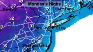
High pressure over the central part of the country will influence our weather through midweek. Readings will be near 40º as the “dig out” takes place today. It would be wise to have all snow removal done by this afternoon as very cold air will work in tonight through Thursday. Temperatures will be below freezing the entire time, but at least the sun will shine.
There are no major precipitation makers on the map through the end of the week.
Keep it here for a no nonsense, no hype forecast.
Today:
Becoming party sunny. Highs around 40º. Northwest winds at 10-20mph.
Tonight:
Mostly clear and much colder. Lows in the lower 20s in the City, the teens inland. Northwest winds at 5-10mph. There will be a refreeze of water and slush.
Tuesday:
Partly sunny, breezy and cold. Highs around freezing.
Wednesday:
Partly sunny, very cold. Highs in the mid 20s.
Thursday:
Partly sunny, cold. Highs around 30º.
Friday:
Partly sunny, not as cold. Highs in the mid 30s.