Synopsis:
The airmass will slowly moderate this weekend as the Arctic air mass releases it’s grip on the tri-statea area. Another high will work in from the West. This high did not originate at the North Pole, meaning much milder temperatures. Readings today will crack the freezing mark.
Punxsutawney Phil doesn’t see’s his shadow today-an early Spring is predicted on this Ground Hog Day. By Sunday it’ll feel like a heatwave as temperatures reach the mid 40s! Both days will feature plenty of sunshine.
Taking a peek at next week, the thaw continues through midweek with readings getting into the 50s.
There are indications that a stationary front will be draped from the Mid-Atlantic to the Ohio Valley late next week. Arctic high pressure will be over Eastern Canada. How much colder air interacts with the system will determine what type of precipitation falls. At this time, it looks like the warm air will win out.
You know where to find a no hype, no nonsense forecast.
Stay tuned.
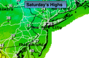
Today:
Mostly sunny and not as harsh Highs in the mid 30s. Southwest winds at 5-10mph.
Tonight:
Partly cloudy and not as cold. Lows around freezing in the City. The 20s inland. West winds at 5mph.
Sunday:
Sunny and mild. Highs in the mid 40s.
Monday:
Partly sunny and mild. Highs near 50º.
Tuesday:
Clouds and sun. Spotty showers. Balmy. Highs in the mid 50s.
Wednesday:
Partly sunny, cooler. Highs in the mid 40s.