Synopsis:
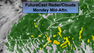
The beginning of the workweek looks unsettled as the jet stream remains active and moisture moves up from the South. Rain will be with us today with an approaching warm front and then again Tuesday with an approaching cool front. The rain today will develop during by mid morning. Readings will be just below the seasonal average of 57º. The steadiest rain on Tuesday will be in the later morning through mid-afternoon. A few thunderstorms are possible. It’ll be milder ahead of the front.
High pressure will be in control Wednesday and Thursday with abundant sunshine and comfortable readings.
It looks like it’ll be a wet close to the workweek on Friday as a low develops over the Mid-Atlantic and moves up the I-95 corridor.
You know where to find a no hype, no nonsense forecast.
Stay tuned.
Today:
Cloudy with rain developing during the mid morning. Highs in the mid 50s. East to Northeast winds increasing 10-2omph.
Tonight:
Areas of light rain or drizzle. Lows in the lower 50s in the City, the 40s inland. Northeast wind at 5-10mph.
Tuesday:
Periods of rain. Chance of a thunderstorm. Mild. Highs in the mid 60s.
Wednesday:
Mostly sunny, breezy and mild. Highs in the lower 60s.
Thursday:
Sunny & seasonal. Highs in the mid 50s.
Friday:
Rain likely. Highs in the mid 50s.
Keep it here for a no nonsense, no hype forecast.